Worcester to Kidderminster
![]()
![]() Follow National Cycle routes 45 and 46 on this lovely route through the Worcestershire countryside. You start near Worcester train station and head north along National Cycle Route 46 to Droitwich Spa passing Worcester racecourse as you go. This section has views of the River Severn and a short stretch by Droitwich Canal.
Follow National Cycle routes 45 and 46 on this lovely route through the Worcestershire countryside. You start near Worcester train station and head north along National Cycle Route 46 to Droitwich Spa passing Worcester racecourse as you go. This section has views of the River Severn and a short stretch by Droitwich Canal.
From Droitwich Spa you join National Cycle route 46 taking you into the countryside and on to Stourport on Severn via Leapgate Country Park and Hartlebury Castle. You then follow the Staffordshire and Worcestershire Canal into Kidderminster finishing by the train station.
Worcester to Kidderminster Ordnance Survey Map  - view and print off detailed OS map
Worcester to Kidderminster Open Street Map  - view and print off detailed map
Worcester to Kidderminster OS Map  - Mobile GPS OS Map with Location tracking
Worcester to Kidderminster Open Street Map  - Mobile GPS Map with Location tracking
Further Information and Other Local Ideas
In Worcester the trail links with the Cotswold Line Cycle Route which runs through the AONB from Worcester to Long Hanborough, just outside Oxford. The trail visits several of the delightful towns and villages of the region with some glorious Cotswolds scenery to enjoy on the way.
Cycle Routes and Walking Routes Nearby
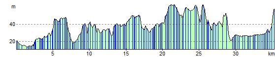
Elevation Profile