York to Selby Railway Walk and Cycle
![]()
![]() This lovely cycle and walk route starts on the banks of the River Ouse in the city of York and follows the Trans Pennine Trail and the York to Selby Railway Path south to Selby.
This lovely cycle and walk route starts on the banks of the River Ouse in the city of York and follows the Trans Pennine Trail and the York to Selby Railway Path south to Selby.
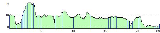
The mostly flat, off road route is ideal for a relaxing afternoon's cycling or walking and has views of York racecourse and the River Ouse. It runs for a distance of about about 16 miles passing Bishopthorpe, Naburn Bridge on the River Ouse, Riccall and Barlby on the way.
In Selby you can continue your exercise at the Selby Canal.
Some of the canal path is available to cyclists or you can walk the whole length if you prefer.
York to Selby Ordnance Survey Map  - view and print off detailed OS map
York to Selby Open Street Map  - view and print off detailed map
*New* - Walks and Cycle Routes Near Me Map - Waymarked Routes and Mountain Bike Trails>>
York to Selby OS Map  - Mobile GPS OS Map with Location tracking
York to Selby Open Street Map  - Mobile GPS Map with Location tracking
Cycle Routes and Walking Routes Nearby
Photos

View of the surfaced path.
_-_geograph.org.uk_-_1465046.jpg)
Mars. The Solar system modelled alongside the path.
_-_geograph.org.uk_-_1465003.jpg)
Saturn. The Trans Pennine Trail along this section also includes a model of the Solar System along the York - Selby cycle track. The Sun is a huge 2.4m (about 8 feet) in diameter and Pluto is a tiny 5.9mm sphere, over 10 Km - that's more than 6 miles - away.

A remnant of the now defunct Selby coalfield alongside the trail.

Naburn Bridge, crossing the River Ouse. The bridge is a disused railway bridge on the old York to Selby line which is now a popular cycle route. The wire sculpture is called the Fisher of Dreams, complete with fisherman, dog and bicycle.

Stillingfleet Beck from the cycleway

Passing through the York racecourse grounds with the former Terry's chocolate works in the centre background.

Canal Basin, Selby. This basin is just above River Lock, where boats can lock down into the tidal River Ouse, providing a through route to York.
Elevation Profile