Aylesbury Ring Circular Walk
![]()
![]() This long circular walk takes you on a tour of the beautiful Aylesbury Vale in Buckinghamshire. It runs for just over 30 miles and includes several pretty villages, canal side walking and a visit to the National Trust's Waddesdon Manor.
This long circular walk takes you on a tour of the beautiful Aylesbury Vale in Buckinghamshire. It runs for just over 30 miles and includes several pretty villages, canal side walking and a visit to the National Trust's Waddesdon Manor.
The path starts and ends in Wendover first heading towards Great Kimble and then onto Dinton where you will find the impressive Dinton Hall. The route continues to Eythrope, crossing the River Thame and passing Eythrope Park and Eythrope Manor House. You continue through the countryside past Waddesdon, Hardwick, Long Marston and the Aylesbury Canal before joining the Wendover Canal Arm near Aston Clinton for the final waterside stretch back to Wendover.
On the canal near Wendover you can take a small detour to visit the picturesque Weston Turville Reservoir where there's lots of water loving birdlife to see on the water.
Aylesbury Ring Ordnance Survey Map  - view and print off detailed OS map
Aylesbury Ring Open Street Map  - view and print off detailed map
Aylesbury Ring OS Map  - Mobile GPS OS Map with Location tracking
Aylesbury Ring Open Street Map  - Mobile GPS Map with Location tracking
Further Information and Other Local Ideas
Around Eythrope you can pick up the circular Haddenham Walk which uses part of this trail and the Thame Valley Walk to visit Dinton, Nether Winchendon and Cuddington. The route starts from Haddenham where there's a pretty duck pond, a fine old church and quaint thatched cottages to see.
For more walking ideas in the area see the Buckinghamshire Walks and the Chilterns Walks pages.
Cycle Routes and Walking Routes Nearby
Photos

A walker on a grassy section of the Aylesbury Ring Path at Butler's Cross

Grand Union Canal below Puttenham Lock. View from the canal bridge of the Aylesbury Arm of the Grand Union Canal which borders this square. Looking West. The Aylesbury Ring walk follows the towpath at this point.

Manor Road to Weedon

House near Starveall Farm, Stone. This unnamed house lies halfway between Starveall Farm about 1/2 km behind the camera, and the A418 road west of Stone. A footpath leaves the left hand side of the near the cottage, and the Aylesbury Ring footpath goes through the farm, but this section of road is not a public way.

Bridleway to Eythrope Park. This track from the North Lodge of Eythrope Park carries several named routes - Swan's Way, Midshires Way, Aylesbury Ring, and North Bucks Way. There are broad beans in fields either side of the hedged track.

Hawthorn hedge in pasture. Photo from public footpath from Long Marston to Hulcott which is part of the trail

The Wendover Arm of the Grand Union Canal. This sign was erected to record the Arm's 200th Anniversary. The Wendover Arm was planned as a feeder to supply water to the Tring Summit of the Grand Junction Canal (now the Grand Union Canal). It was completed as a navigable canal in 1797 and operated as such throughout the 19th century. The Towpath is part of the trail. This section starts with the former Wendover Wharf and a winding hole, and also includes a wooden footbridge on the site of an earlier railway bridge

Wendover Arm, The Start of the Grand Union Canal Walk. A dog makes its way along the towpath with boats in the background.
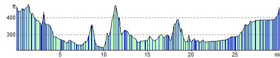
Elevation Profile