Baker Way
![]()
![]() Take a stroll along the Baker Way from Chester to Delamere Forest on this pleasant, varied walk.
Take a stroll along the Baker Way from Chester to Delamere Forest on this pleasant, varied walk.
The walk starts at Chester railway station and heads east along the Shropshire Union Canal to Rowton.
You then leave the canal and head through the countryside to Tarvin which is an excellent place to stop for a pub lunch. The final section of the walk takes you from Tarvin to the lovely Delamere Forest Park where the route finishes at Delamere Station.
This is a pleasant and fairly easy walk with waterside, countryside and woodland sections to enjoy.
Baker Way Ordnance Survey Map  - view and print off detailed OS map
Baker Way Open Street Map  - view and print off detailed map
*New* - Walks and Cycle Routes Near Me Map - Waymarked Routes and Mountain Bike Trails>>
Baker Way OS Map  - Mobile GPS OS Map with Location tracking
Baker Way Open Street Map  - Mobile GPS Map with Location tracking
Pubs/Cafes
In Christleton the Cheshire Cat is located in a lovely spot next to the canal. The dog friendly inn dates back to 1801 and serves good quality food. You can find them at Whitchurch Rd, Christleton, CH3 6AE.
Cycle Routes and Walking Routes Nearby
Photos

This image is looking northwest along the Shropshire Union Canal towpath, adjacent to the Cheshire Cat pub in Christleton. Baker Way: A route linking Chester with Delamere Forest Park. The Way follows a mix of canal towpaths, quiet roads, field paths and forest tracks. The route starts and finishes at railway stations so you can leave the car at home.

Hockenhull Hatchery, Hockenhull. View from bridleway Hockenhull 1 (part of the Baker Way) on bearing of 70 deg, distance about 80m. Two facets of the Cheshire farming scene in this tiny rural parish near Tarvin. The curious heifer stands in front of the hatchery, which belongs to British United Turkeys and is run as part of the turkey farm at nearby Hockenhull Hall

Forest track in early spring. An area of deciduous woodland, predominantly beech and birch trees, in the north west of Linmere Moss area of Delamere Forest. The Baker Way and Sandstone Trail coincide along this forest track north of the railway line

A place to rest in Delamere Forest

Christleton Bridge and towpath of the Shropshire Union Canal

Chester - the shot tower beside the Shropshire Union Canal
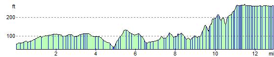
Elevation Profile