Barbon Beck Barbondale

 This lovely valley in the Cumbrian section of the Yorkshire Dales is a great place for a peaceful, waterside walk. It can also be made into a challenging circular walk by climbing Castle Knott Hill and Calf Top Hill.
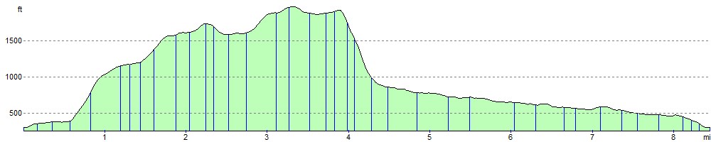
The circular walk starts from the village of Barbon which is located just a few miles north east of Kirkby Lonsdale. The Barbon Beck runs through the village to the River Lune, about one mile to the west. After leaving the village you climb to Eskhome Pike, Castle Knott Hill and Calf Top Hill. It's a challenging climb with Calf Top Hill reaching a height of 609m (2000 ft). From the high points there are splendid views of the surrounding fells and countryside.
The route then descends from Calf Top to Hanging Clint and Rowel Gill. Here you pick up the much easier path along the beck through Barbondale. On the way you'll pass a series of pretty waterfalls and a woodland section at Barbon Manor.
For an easier walk you can just take the southern section of the path along the Beck which is very flat.
To extend your walking in the area you could head to Kirkby Lonsdale, pick up the Lune Valley Ramble and enjoy another waterside walk along the River Lune.
You could also follow the Limestone Link to Hutton Roof Crags and Farleton Fell where you will find some of the finestálimestone pavement in the country.
Postcode
LA6 2LJ - Please note: Postcode may be approximate for some rural locationsBarbon Beck Barbondale Ordnance Survey Map  - view and print off detailed OS map
Barbon Beck Barbondale Open Street Map  - view and print off detailed map
Barbon Beck Barbondale OS Map  - Mobile GPS OS Map with Location tracking
Barbon Beck Barbondale Open Street Map  - Mobile GPS Map with Location tracking
Pubs/Cafes
Back in Barbon village there's the Barbon Inn for post walk refreshments. The 17th century former coaching inn serves high quality dishes and provides accommodation too. There's an attractive garden area which is popular with walkers and cyclists looking for a peaceful spot to relax in. You can find them at postcode LA6 2LJ.
Another option is to head into nearby Kirkby Lonsdale and visit the Snooty Fox. The classic old pub dates from the 17th century and has an excellent menu. There's also a nice beer garden to relax in on warmer days. You can find it in the attractive market town on Main Street with a postcode of LA6á2AH for your sat navs.
Dog Walking
The beck and fells make for a fine walk for fit dogs. The Barbon Inn mentioned above is also very dog friendly.
Further Information and Other Local Ideas
The village is not far from the coastal town of Carnforth where you could enjoy an easy waterside stroll on the Carnforth Canal Walk.
Just to the north is Sedbergh where there's the River Dee - Dentdale Walk and the Sedbergh Circular Walk to try around the town.
For more walking ideas in the area see the Cumbria Walks page.
Cycle Routes and Walking Routes Nearby
Photos

Hodge Bridge, Barbon

A track in Barbondale

The Barbon Beck

Ford across Barbon Beck

Castle Knott

Wall on Calf Top

Barkin Top. Part of the ridge along the edge of Middleton Fell which formed the old Westmorland-Yorkshire border, now the Yorkshire Dales National Park boundary.

A lovely pair of cottages in the village of Barbon in Cumbria.
Elevation Profile