Beeches Way - Cookham to Yiewsley and West Drayton Walk
![]()
![]() Follow the Beeches Way through the Chilterns from the River Thames at Cookham to the Grand Union Canal at West Drayton.
Follow the Beeches Way through the Chilterns from the River Thames at Cookham to the Grand Union Canal at West Drayton.
You start off at Cookham and head east to the wooded Burnham Beeches Nature Reserve. The reserve covers over 500 acres with a network of great woodland trails. There's also ponds, grassland, heathland with wildlife which includes Exmoor Ponies. The walk then passes through Fulmer before a lovely stretch through Black Park Country Park and Langley Park Country Park. The final stretch takes you around the lakes in Colne Valley Regional Park before finishing on the Grand Union Canal at West Drayton.
Beeches Way Ordnance Survey Map  - view and print off detailed OS map
Beeches Way Open Street Map  - view and print off detailed map
Beeches Way OS Map  - Mobile GPS OS Map with Location tracking
Beeches Way Open Street Map  - Mobile GPS Map with Location tracking
Pubs/Cafes
At the visitor centre in Burnham Beeches there's a lovely tea room where you can sit outside in a wooded glade. There's light bites, nice cakes and ice cream to refresh yourself here after your exercise.
If you would like to sample one of the local pubs we recommend the splendid Blackwood Arms Country Pub. There's great food, a cosy fire indoors, and a delightful garden area with nice views of the countryside. It's perfect for relaxing in on warmer days. You can find the pub at address Common Lane, Littleworth Common, with a postcode of SL1 8PP for your sat navs.
The path passes close to the worthy village of Wooburn Green near Beaconsfield. There's a pleasant large green here with a number of historic properties. There's also a pretty local park with walks along the River Wye and peaceful adjacent woodland. In the village there's The Old Bell. This pub dates back to the 16th century and sits next to the church in the attractive conservation area of Wooburn Town. There's fine food and a great sun trap garden to enjoy here. You can find them just off the route on Town Lane at postcode HP10 0PL.
Cycle Routes and Walking Routes Nearby
Photos

Burnham Beeches is owned by the Corporation of London. This ancient woodland is a National Nature Reserve.

East Burnham Common in Burnham Beeches
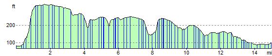
Elevation Profile