Ben Lomond Walk
![]()
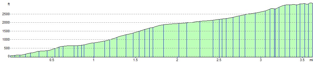
![]() Climb one of Scotland's most popular munros on this challenging walk in the Loch Lomond and the Trossachs National Park. The mountains sits on the eastern shore of Loch Lomond rising to a height of 974 metres (3,196 ft). The climb takes place on a good path with a steady gradient, starting from the Rowardennan car park. The first section takes you through woodland towards Coire Corrach. You continue the ascent to Sron Aonaich and Sithean before reaching the summit where there are fabulous views across Loch Lomond & the Trossachs National Park.
Climb one of Scotland's most popular munros on this challenging walk in the Loch Lomond and the Trossachs National Park. The mountains sits on the eastern shore of Loch Lomond rising to a height of 974 metres (3,196 ft). The climb takes place on a good path with a steady gradient, starting from the Rowardennan car park. The first section takes you through woodland towards Coire Corrach. You continue the ascent to Sron Aonaich and Sithean before reaching the summit where there are fabulous views across Loch Lomond & the Trossachs National Park.
If you would like to continue your walking in the area then you pick up the West Highland Way and enjoy a walk along Loch Lomond.
Postcode
G63 0AR - Please note: Postcode may be approximate for some rural locationsBen Lomond Ordnance Survey Map  - view and print off detailed OS map
Ben Lomond Open Street Map  - view and print off detailed map
Ben Lomond OS Map  - Mobile GPS OS Map with Location tracking
Ben Lomond Open Street Map  - Mobile GPS Map with Location tracking
Pubs/Cafes
The Rowardennan Hotel sits in a great location on the banks of Loch Lomond, with fine views over the water. The hotel dates back to 1696 but has been recently refurbished in a contemporary Scottish style.
Inside there's a cosy wood burning fire for colder days. Outside there's a Beer Garden and a little beach by the loch. They serve good wholesome food and can be found at postcode G63 0AR for your sat navs. The hotel is also dog friendly.
Further Information and Other Local Ideas
To the north west there's another hugely popular climb at The Cobbler. The mountain gets its name from the distinctive, large rocky summit which look like a cobbler bending over his last.
The Rowardennan to Inversnaid Walk will take you along the West Highland Way to Inversnaid where you could visit another local highlight at Inversnaid Falls.
For more walking ideas in the area see the Loch Lomond and the Trossachs Walks page.
Cycle Routes and Walking Routes Nearby
Photos

View north from the summit.

Nearing the summit of Ben Lomond. This is a false summit, the true summit is actually a little further to the west.

Ptarmigan ridge

Looking to Beinn Bhan from Ben Lomond
Elevation Profile