Bere Alston and Bere Ferrers Peninsula Circular
![]()
![]() This circular ride/walk takes you along the River Tamar and then the River Tavy with splendid views of the beautiful Tamar Valley AONB. You start at Bere Ferrers and head north along the River Tamar to Bere Alston before the route returns to its origin along the River Tavy. You will also pass near to the beautiful Lopwell Dam which is worth the small detour as you return. The nature reserve consists of a variety of different habitats including mudflats, freshwater marsh, wildflower meadow, scrub-grassland, saltmarsh and semi-natural woodland.
This circular ride/walk takes you along the River Tamar and then the River Tavy with splendid views of the beautiful Tamar Valley AONB. You start at Bere Ferrers and head north along the River Tamar to Bere Alston before the route returns to its origin along the River Tavy. You will also pass near to the beautiful Lopwell Dam which is worth the small detour as you return. The nature reserve consists of a variety of different habitats including mudflats, freshwater marsh, wildflower meadow, scrub-grassland, saltmarsh and semi-natural woodland.
The ride is easy to access from Bere Ferrers railway. It includes a few steep climbs but with terrific views at the high points. Much of the route follows the Tamar Valley Discovery Trail so is also suitable for walkers.
Bere Peninsula Circular Ordnance Survey Map  - view and print off detailed OS map
Bere Peninsula Circular Open Street Map  - view and print off detailed map
Bere Peninsula Circular OS Map  - Mobile GPS OS Map with Location tracking
Bere Peninsula Circular Open Street Map  - Mobile GPS Map with Location tracking
Further Information and Other Local Ideas
The Tamar Valley Line has a train station at Bere Ferrers. It's is a great way of seeing the area from a different perspective. The scenic railway takes you through rolling green, sleepy villages and beautiful river crossings. The highlight of the journey is when the train slowly creeps down over the impressive Calstock viaduct and you are 120 feet high looking down on the river below.
Cycle Routes and Walking Routes Nearby
Photos

Riverside cottages at Bere Ferrers. On the corner of Hensbury Lane. The Tamar Valley Discovery Trail follows the track in front of the cottages up to Hallowdene, crossing the river at Lopwell Dam

Bere Ferrers: the Tamar by Weir Quay. Looking west: the river comes snaking down past Pentillie Castle behind the strip of land beyond the vessels to run by Hole’s Hole and Weir Quay. Off shot to the left it heads for Cargreen and beyond, where it is joined by the river Tavy

Weir Quay near Bere Alston. Looking south down the River Tamar. The opposite bank is in Cornwall

River Tavy at Bere Ferrers

Cottages north of Weir Quay

Whittacliffe Wood
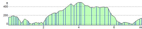
Elevation Profile