Berrys Green Circular Walk
![]()
![]() This pleasant circular walk passes through the woods and villages around the rural area of Berry's Green in Bromley.
Highlights on the walk include the pretty village of Cudham and views of Biggin Hill Airport and Cherry Lodge Golf Club.
This pleasant circular walk passes through the woods and villages around the rural area of Berry's Green in Bromley.
Highlights on the walk include the pretty village of Cudham and views of Biggin Hill Airport and Cherry Lodge Golf Club.
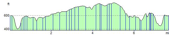
The circular route runs for about 8 miles on reasonably flat trails with some fairly small climbs on the way.
Berrys Green Circular Ordnance Survey Map  - view and print off detailed OS map
Berrys Green Circular Open Street Map  - view and print off detailed map
Berrys Green Circular OS Map  - Mobile GPS OS Map with Location tracking
Berrys Green Circular Open Street Map  - Mobile GPS Map with Location tracking
Pubs/Cafes
The Blacksmith Arms in Cudham is a historic pub of some note. The old inn was built during the reign of Charles I (1625 – 1649) in the year 1628. The property at this time is described as a farm dwelling with stables. These days it's a fine country pub with a good menu and selection of ales. There's also a lovely garden area where you can enjoy your refreshment outside on warmer days. You can find the pub on Cudham Lane at a postcode of TN14 7QB for your sat navs. The inn is also dog friendly if you have your canine friend with you.
Further Information and Other Local Ideas
To continue your walking in the area try the Cudham Circular Walk.
To the south is Betsoms Hill, the highest point in the county of Kent. This area also includes Westerham Heights, the highest point of Greater London.
For more walking ideas in the area see the Greater London Walks and the Kent Walks pages.
Cycle Routes and Walking Routes Nearby
Photos

Footpath to Berry's Green

Cudham cricket pitch

Single Street, Berry's Green TN16

Littlewood Farm

By the Cherry Lodge golf course

Farm buildings, Cudham Grange, Kent
Elevation Profile