Beverley Brook Walk London with OS Map
![]()
![]() This walk follows the Beverley Brook from the River Thames at Putney to New Malden. The trail passes through Barnes Common, Richmond Park and Wimbledon Common, exposing you to some of South London's most attractive countryside.
This walk follows the Beverley Brook from the River Thames at Putney to New Malden. The trail passes through Barnes Common, Richmond Park and Wimbledon Common, exposing you to some of South London's most attractive countryside.
Walk highlights include the Beverley Meads and Fishpond Local Nature Reserve where Kingfishers and Mandarin Ducks may be seen. At Barnes you will pass near to the splendid Wildfowl and Wetlands Centre, where you can see a wide variety of wildlife including lapwings, little ringed plovers, great crested and little grebes, gadwall, mallards, pochards and tufted duck broods. There is also a section through the delightful Richmond Park where you can look out for the resident deer.
The walk is easily accessible from the train station at New Malden or from the nearby East Putney Tube or Putney train station.
Please click here for more information
Beverley Brook Walk Ordnance Survey Map  - view and print off detailed OS map
Beverley Brook Walk Open Street Map  - view and print off detailed map
*New* - Walks and Cycle Routes Near Me Map - Waymarked Routes and Mountain Bike Trails>>
Beverley Brook Walk OS Map  - Mobile GPS OS Map with Location tracking
Beverley Brook Walk Open Street Map  - Mobile GPS Map with Location tracking
Further Information and Other Local Ideas
Head along the river to nearby Kingston and you can pick up the Hogsmill River Walk. It's a similar route following a small chalk stream tributary of the River Thames to Bourne Hall Park in Surrey based Ewell.
You can also explore Beverley Westwood, a large area of common land with grazing cattle, a network of footpaths and the historic Black Mill.
For more walking ideas in the area see the London Walks page.
Cycle Routes and Walking Routes Nearby
Photos

The brook, running towards the camera, emerges from woodland at Killcat Corner past pollarded willows. Hidden on the other bank is the Richmond Park Golf Course.

Richmond Park. The Brook, which flows out into the River Thames near Barnes, forms the eastern boundary of the park here. The protective fencing around the trees is still in place even though the trees are well-established.

Motspur Park. This was taken looking downstream from the Motspur Park / West Barnes Lane road bridge. The boundary between the London Boroughs of Merton, to the right, and Kingston upon Thames, to the left, runs down the centre of the brook at this location.

Beverley Bridge. The bridge carries the A3 road over Beverley Brook here between Kingston Vale to the left and Putney Vale to the right. There has been a bridge here since historic times, but the current structure dates from the early eighteenth century when the road to Portsmouth from London became strategically important. It has been much altered and widened through the years.

Near Roehampton Gate in Richmond Park

West Barnes Lane and Motspur Park. The bridge here carries the road over Beverley Brook. The white post against the bridge parapet is a boundary marker. It shows the boundary between the former Boroughs of Malden and Coombe to the left and Merton and Morden to the right. During the reorganization of local government in the 1960s, the former became part of the London Borough of Kingston upon Thames, and the latter became part of the London Borough of Merton. The current boundary between these Boroughs still follows the original line through the marker. The sign on the post on the left shows that you are entering the Royal Borough of Kingston upon Thames. The road changes its name from Motspur Park to West Barnes Lane either side of the boundary post.

East Sheen. Looking downstream from the footbridge near Palewell Park, the brook is about three kilometres from its confluence with the River Thames here. As is usual with these London urban watercourses a local government boundary runs down the brook, or in this case on the right bank. The brook, and the land to the left, are in the London Borough of Richmond upon Thames, while the trees on the right and the land beyond are in the London Borough of Wandsworth.

Wimbledon Common. The brook forms the western boundary of the common, and is viewed here looking upstream.
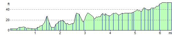
Elevation Profile