Bridgnorth Walks
![]()
![]() This fine Shropshire town has some fine walking trails through the Severn Valley and a number of local parks and gardens to explore.
This fine Shropshire town has some fine walking trails through the Severn Valley and a number of local parks and gardens to explore.
This long walk from the town centre makes use of the Severn Way and Geopark Way long distance trails to take you on a tour of the countryside to the south of the town. On the way you'll visit the Severn Valley Country Park, Chelmarsh Reservoir and Dudmaston Hall while enjoying long riverside stretches along the River Severn.
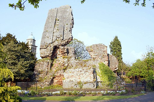
The walk starts in the town centre at the ruins of Bridgnorth Castle. The castle dates from the early part of the 12th century and is surrounded by pretty gardens. From here you can pick up the Severn Way running along the western side of the river. You head south passing Eardington before coming to Hampton Loade where you have the option of taking a detour to visit the nearby Chelmarsh Reservoir. The Jack Mytton Way runs along the northern end of the reservoir with nice views across the water.
At Hampton you also have the option of catching the Severn Valley Railway back to Bridgnorth to shorten the walk. This route continues south to Highley where you cross the river and enter Severn Valley Country Park. The lovely 126-acre riverside park consists of woodland, meadows, a lake and riverside banks. Here you pick up the Geopark Way and follow it through the park toward Alveley. The route then turns north, passing Hampton Loade and a woodland section before coming to the noteworthy Dudmaston Hall. The fine 17th-century country house is surrounded by landscaped gardens, parkland, managed woodlands, lakes and farmland. The area also includes the adjacent Comer Woods. The tranquil woods have their own car park and entrance and are free to access. There's a number of picturesque pools and lots of woodland birds to see in this area.
The route then heads through the woodland north of Dudmaston before passing Quatford and returning to the river for a final waterside stretch which leads you back into Bridgnorth.
The town is also located close to Stanmore Country Park which is a great place to continue your walking in the area. Also of interest is the expansive Wyre Forest and the Sabrina Way long distance trail which passes through the town.
The Severn Valley Railway Walk takes you further along the wonderful old heritage railway around Bewdley and Upper Arley.
Bridgnorth Ordnance Survey Map  - view and print off detailed OS map
Bridgnorth Open Street Map  - view and print off detailed map
Bridgnorth OS Map  - Mobile GPS OS Map with Location tracking
Bridgnorth Open Street Map  - Mobile GPS Map with Location tracking
Walks near Bridgnorth
- Severn Valley Country Park - This 126-acre riverside park consists of woodland, meadows and riverside banks with views of the River Severn
- Severn Valley Railway Walk - Enjoy a lovely walk along the Severn Valley Railway on this riverside trail in Bewdley
- Dudmaston Hall - This 17th-century country house in the Severn Valley is surrounded by landscaped gardens, parkland, managed woodlands, lakes and farmland.
- Stanmore Country Park Shropshire - This 100 acre country park near Bridgnorth is ideal for a peaceful afternoon stroll
- Sabrina Way - This route is part of the National Bridleroute Network and primarily designed for horse riders but can be used by walkers and cyclists also
- Wyre Forest - This large forest near Bewdley has miles of super cycling and walking trails to enjoy
- Badger Dingle - This walk visits the delightful Badger Dingle Waterfall in the Shropshire village of Badger.
- Albrighton - This large Shropshire based village is located close to Telford and Bridgnorth
- Hampton Loade - This pretty riverside village is located on the Severn Valley Railway in Shropshire
- Button Oak - This circular walk visits the village of Button Oak in the Wyre Forest near Bewdley.
- Comer Woods - This walk explores Comer Woods in Shropshire
- Severn Way - Follow the River Severn from its source at Plynlimon in Powys, to Bristol, the mouth of the river
- Geopark Way - Meandering its way for 109 miles through the Abberley and Malvern Hills Geopark from Bridgnorth to Gloucester, the Geopark Way passes through stunning countryside as it explores 700 million years of geological history
- Worfield - This little Shropshire village has some pleasant walks through the River Worfe Valley to try
Further Information and Other Local Ideas
Just to the north east there's a bit of a hidden gem at Badger Dingle. There's a delightful little wood here with a brook, pools, sandstone outcrops and a rushing waterfall to admire.
To the east there's Worfield where you can enjoy some pleasant trails through the valley of the River Worfe. The historic village is also worthy of exploration with its Saxon church, half timbered houses and the 18th century Davenport House.
For more walking ideas in the area see the Shropshire Walks page.


