Buckingham Walks
![]()
![]() This interesting market town is located in north Buckinghamshire, near to the borders of Northamptonshire and Oxfordshire. It's surrounded by some lovely countryside with other highlights including the River Great Ouse, the Grand Union Canal and the magnificent Stowe Park.
This interesting market town is located in north Buckinghamshire, near to the borders of Northamptonshire and Oxfordshire. It's surrounded by some lovely countryside with other highlights including the River Great Ouse, the Grand Union Canal and the magnificent Stowe Park.
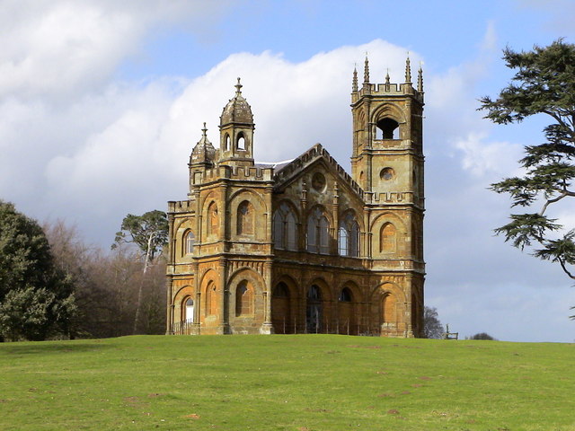
This circular walk from the town takes you to the beautiful Stowe Park, just to the north east. The walk starts in the town centre where you can pick up footpaths running north through the countryside toward Chackmore. Shortly after you come to Stowe where you can follow public footpaths around the perimeter of the site. On the way there are nice views across the historic parkland and woodland. For a fee you can access all of the grounds which are run by the National Trust. There are stunning gardens to see with other highlights including the Grecian Valley, the Gothic Temple, the Temple of Friendship and the Palladian bridge.
On the western side of the park you'll cross the picturesque Oxford Water on an old bridge before returning to the town on Stowe Avenue.
Postcode
MK18 1EP - Please note: Postcode may be approximate for some rural locationsBuckingham Ordnance Survey Map  - view and print off detailed OS map
Buckingham Open Street Map  - view and print off detailed map
Buckingham OS Map  - Mobile GPS OS Map with Location tracking
Buckingham Open Street Map  - Mobile GPS Map with Location tracking
Walks near Buckingham
- Stowe Park - Explore 250 acres of stunning parks and gardens at this major Buckingham attraction
- Claydon House - This circular walk takes you through the countryside surrounding Claydon House in Middle Claydon, near Buckingham
- Palladian Way - Walk from Buckingham to Bath through the beautiful countryside of Buckinghamshire, Gloucestershire, Oxfordshire and Wiltshire on this trail named after Andre Palladio's Italian architecture
- Brill Tramway Trail - This short circular walk follows the bed of the Brill tramway, through Quainton, Westcott and Waddesdon
- Bernwood Jubilee Way - Explore the Ancient Royal Forest of Bernwood on this circular walk devised to celebrate the Queen's Golden Jubilee
- Westbury Circular Ride - This is a circular walk or cycle ride around Westbury in Buckinghamshire
- Grand Union Canal Walk - Follow the towpath of Britain's longest canal from London to Birmingham on this fabulous waterside walk
- Ouse Valley Way - Follow the River Great Ouse from the source at Brackley, Northamptonshire, to the mouth at The Wash at King's Lynn
- Buckingham Railway Walk - This easy walk follows a nice footpath along the old Buckingham railway line near the centre of Buckingham
- Tusmore Park Estate - This walk explores the Tusmore Park Estate, near Bicester in Oxfordshire.
- Stoke Wood - These ancient woods are located near Bicester in Oxfordshire
Pubs/Cafes
Head to The Woolpack in the town centre for some refreshments after your walk. The friendly pub has cost fires indoors and a large garden overlooking the river outside. It's a lovely spot to rest in on warmer days. You can find the pub on Well Street at postcode MK18 1EP. The pub is also dog friendly if you have your canine friend with you.
The Mitre is the oldest pub in Buckingham and located near to the university. The 17th century pub has a fantastic garden and patio area here if the weather is good. Inside there's a cosy real open fire as well as a new log burner in winter. You can find the pub at 2 Mitre Street with a postcode of MK18 1DW for your sat navs.
Further Information and Other Local Ideas
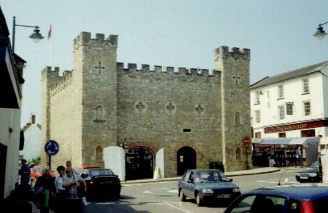
In the town head to the Buckingham Old Gaol Museum which tells the story of Buckingham, including the Flora Thompson Collection (author of Lark Rise to Candleford) and Buckinghamshire Military Trust exhibits. The museum is housed in the Old County Gaol, built in 1748 and one of the iconic buildings of the town.
On the western side of the town there's the pretty Buckingham Railway Walk. This follows a delightful footpath along the old Buckingham railway line near to the university. It's a lovely place for a peaceful stroll in the town with lots of flora and fauna to see.
The Palladian Way long distance trail also starts from the town. The epic, waymarked trail runs all the way to Bath through four different counties.
Just to the west of Stowe Park you can pick up the Westbury Circular Ride. This shared cycling and walking trail explores the area around the nearby village of Westbury. If you head west it will take you towards Turweston and Brackley in Northamptonshire. The interesting market town is close to the famous Silverstone racing track and includes a noteworthy Parish church with parts dating from the 11th century.
Heading off to the east of the town is the Buckingham Arm of the Grand Union Canal Walk. You could follow it east towards a reservoir, Thornton and Bourton Meadow. The little park is another lovely place for a waterside stroll and can be found just to the east of the town next to the canal and River Ouse.
For more walking ideas in the area see the Buckinghamshire Walks page.


