Castle Howard Walks
![]()
![]() The 1000 acres of parkland and gardens surrounding this stately home is a walker's paradise. There are peaceful woodland trails, two large lakes, a series of ponds, formal gardens and fountains. There's a lovely walled garden with romantic Italianate trellises and peaceful woodland trails in the Yorkshire Arboretum. The Arboretum covers 120 acres and includes a wonderful collection of trees from all over the world. There's also beautiful rhododendrons and a wildflower meadow to enjoy. All the while there is the beautiful surrounding countryside of the Howardian Hills making a splendid backdrop.
The 1000 acres of parkland and gardens surrounding this stately home is a walker's paradise. There are peaceful woodland trails, two large lakes, a series of ponds, formal gardens and fountains. There's a lovely walled garden with romantic Italianate trellises and peaceful woodland trails in the Yorkshire Arboretum. The Arboretum covers 120 acres and includes a wonderful collection of trees from all over the world. There's also beautiful rhododendrons and a wildflower meadow to enjoy. All the while there is the beautiful surrounding countryside of the Howardian Hills making a splendid backdrop.
The house itself has been categorised as 'One of the World's Top Ten Greatest Mansions and Grand Houses' in Lonely Planet's 1,000 Ultimate Sights. It was used as the fictional 'Brideshead', in the 1981 TV adaptation of Evelyn Waugh's Brideshead Revisited and the two-hour 2008 remake for cinema.
The Centenary Way runs past the estate so you could easily pick this up and extend your walk into this AONB. The lovely village of Terrington is nearby so you could head there and enjoy a circular walk exploring the woodland, farmland and hills surrounding the village.
Also nearby is the town of Malton where there are riverside paths along the River Derwent and a fascinating Roman Fort to see.
Postcode
YO60 7DA - Please note: Postcode may be approximate for some rural locationsPlease click here for more information
Castle Howard Ordnance Survey Map  - view and print off detailed OS map
Castle Howard Open Street Map  - view and print off detailed map
*New* - Walks and Cycle Routes Near Me Map - Waymarked Routes and Mountain Bike Trails>>
Castle Howard OS Map  - Mobile GPS OS Map with Location tracking
Castle Howard Open Street Map  - Mobile GPS Map with Location tracking
Pubs/Cafes
There are a number of fine on site cafes and shops at the expansive site.
Dog Walking
The grounds are a great place for a dog walk with miles of woodland and parkland trails to explore with your friend. The on site cafes are also dog friendly with water bowls available. Free bones can also be obtained from the Farm Shop. You are requested to keep them on leads throughout the site.
Further Information and Other Local Ideas
The Hovingham Walk visits the site from the nearby village by following the Ebor Way and Centenary Way through the local woodland and countrysidfe. The idyllic village is well worth a visit with a historic Saxon Church, a picturesque cricket pitch by the 18th century Hovingham Hall, a pretty beck and two fine hotels to relax in after your exercise. Slingsby and its noteworthy 18th century pub can also be found in this area.
For more walking ideas in the area see the Howardian Hills Walks page.
Cycle Routes and Walking Routes Nearby
Photos
Castle Howard, south elevation. The view of the house from the south. Taken from the track that runs east from the Pyramid Gate.
Courtyard cafe. Part of the stable block buildings of the 1780s are now used as a cafe. In the centre of the courtyard is the original pump used to supply water for the horses.
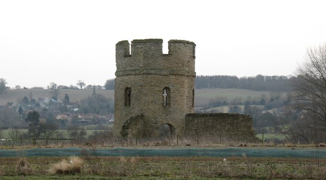
'Gothic' ruin. Running East to West close to the 18th century gatehouse at Castle Howard is a line of mock medieval defences comprising walls and towers. This is the easternmost of the towers, close to two footpaths. The village of Welburn can be seen in the distance.
Garden Centre. One of the commercial ventures at Castle Howard is this garden centre on the south side of the stable block.
Gardener's Cottage. This must be one of the most elegant gardener's cottages in Britain. No information could be found about the house, but its position near the stable block, its design and its construction, would suggest that it was designed by John Carr and probably dates from the 1780s.
The woodlands feature a mix of deciduous and coniferous trees, including ancient oak, beech, sycamore, and Scots pine. The understorey supports species such as hazel, holly, and bramble. In spring, the woodland floors come alive with bluebells, wild garlic, and wood anemones, while ferns and mosses thrive in the shaded areas. The estate's landscaped gardens are home to a range of ornamental plants, including rhododendrons, azaleas, and various perennial flowers.
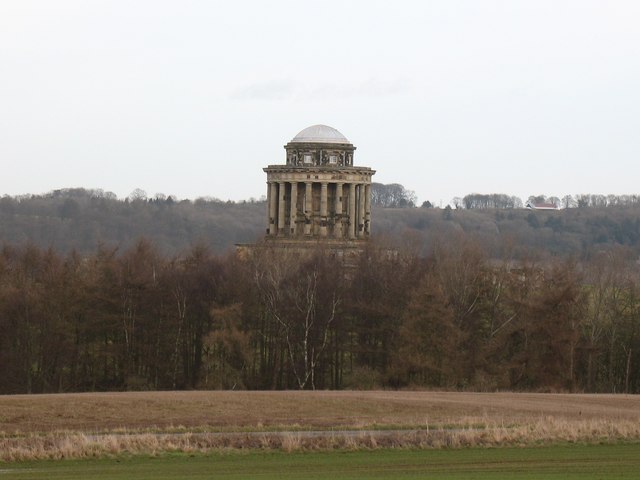
The Mausoleum. The huge mausoleum in the grounds of Castle Howard was designed by Hawksmoor in 1729, but the building was not completed until 1742. Only the upper part of the building is seen here over the trees, with 20 columns supporting the drum and dome roof.
The Great Lake. The Great Lake is an entirely artificial construction dating from the 1790's. A long embankment along the eastern side dams the lake, the level of which is well above the adjoining caravan site.
Wildlife in the Castle Howard grounds is varied. The woodlands provide shelter for mammals such as roe deer, red squirrels (in certain areas where conservation efforts are active), badgers, and foxes. Birdlife is abundant, with species like great spotted woodpeckers, nuthatches, tawny owls, and buzzards commonly observed. The estate's open areas and lakes attract waterfowl, including mallards, tufted ducks, herons, and occasionally swans.


