Catrigg Force Walk
![]()
![]() This circular walk visits the beautiful Catrigg Force waterfall in the Yorkshire Dales. It's a wonderful spot and can be easily reached from Stainforth. This longer walk starts at Settle and involves some more challenging hill climbing.
This circular walk visits the beautiful Catrigg Force waterfall in the Yorkshire Dales. It's a wonderful spot and can be easily reached from Stainforth. This longer walk starts at Settle and involves some more challenging hill climbing.
After leaving Settle you climb towards Attimire Scar where you can see a series of caves and interesting limestone formations. You then descend to the waterfall, passing Jubilee Cave, Victoria Cave and Winskill Stones - a 74-acre area of limestone grassland and limestone pavement. The area is also a nature reserve with a wide variety of plants and wildflowers, such as sandwort, horseshoe vetch, meadow saxifrage, mossy saxifrage, mountain everlasting and moonwort.
Shortly after passing through Wainskill Stones you come to Catrigg Force. The waterfall has 2 main drops of about 20 feet and a series of smaller waterfalls. It's a delightful area, with peaceful woodland and the Stainforth Beck to enjoy.
The route then continues to Stainforth before picking up the Ribble Way and following the River Ribble back to Settle. This lovely waterside section also passes the Stainforth Force Waterfall.
If you'd like to continue your walking in the area then you could head to the nearby Malham Tarn Estate or continue along the Ribble Way.
The beautiful Scaleber Force waterfall is also only a two mile walk from Settle. Our Settle Caves and Waterfalls Walk visits both falls and the series of mysterious caves to the east of the town.
The falls can be easily reached from the nearby village of Stainforth where you can also visit the lovely Stainforth Force waterfalls on the Settle Riverside Walk.
Catrigg Force Ordnance Survey Map  - view and print off detailed OS map
Catrigg Force Open Street Map  - view and print off detailed map
*New* - Walks and Cycle Routes Near Me Map - Waymarked Routes and Mountain Bike Trails>>
Catrigg Force OS Map  - Mobile GPS OS Map with Location tracking
Catrigg Force Open Street Map  - Mobile GPS Map with Location tracking
Further Information and Other Local Ideas
On the opposite side of the River Ribble to Settle you'll find the nearby village of Giggleswick. Here you could pick up the circular Giggleswick Walk and enjoy a climb to the excellent viewpoints on Giggleswick Scar.
For more walking ideas in the area see the Yorkshire Dales Walks page.
Cycle Routes and Walking Routes Nearby
Photos

Walled Track towards Catrigg Force. This typical Yorkshire Dales walled track leads up to Catrigg Force from the village of Stainforth.

Entrance to Catrigg Force. The signpost says Catrigg Foss. In the distance is Pen y Ghent

View of the falls and surrounding vegetation. Taken in the summer of 2008

Rough Grazing land north of Catrigg Force. A general view looking north which shows typical Yorkshire Dales 'lower' grazing land. Further north Pen y ghent dominates the skyline.

Village of Stainforth as you enter from the path to Catrigg Force

The top of Catrigg Force plunging down its gorge.
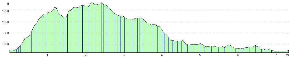
Elevation Profile