Centenary Circle Chelmsford
![]()
![]() This circular walk takes you through the parks and countryside around Chelmsford.
This circular walk takes you through the parks and countryside around Chelmsford.
The walk starts on Sandford Mill bridge on the Chelmer and Blackwater Navigation and passes Sandon, Chignal Smealey, Galleywood, Writtle and Broomfield. Highlights on this walk include Hylands Park with the Grade II listed Hylands House and gardens.
South of Chelmsford you'll pass Galleywood Common. It's a very pleasant and peaceful area with woodland trails and open grassland.
Also look out for the 17th century New Hall school. Founded in 1642 it is one of the oldest Catholic schools in England. Finally there is a lovely waterside section along the Chelmer and Blackwater Navigation taking you back to Sandford Mill and route end.
Centenary Circle Ordnance Survey Map  - view and print off detailed OS map
Centenary Circle Open Street Map  - view and print off detailed map
Centenary Circle OS Map  - Mobile GPS OS Map with Location tracking
Centenary Circle Open Street Map  - Mobile GPS Map with Location tracking
Cycle Routes and Walking Routes Nearby
Photos

The edge of Broomfield. The Centenary Circle path emerges into countryside

Stacey's Farm

Pond west of Stacey's Farm

Part of Chelmsford Centenary Circle near Hyland's House. The Centenary Circle covers many public footpaths and bridleways, etc. around the Chelmsford area and is just over 20 miles long. It is cared for by Essex County Council.

Hylands House

Sandford Mill Lock, Chelmer ^ Blackwater Navigation
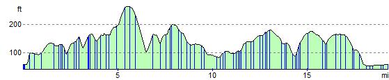
Elevation Profile