Cothelstone Hill
![]()
![]() Enjoy heathland, woodland and wonderful views on this circular walk in the Quantocks. It's a lovely area with the groups of beech trees known as the Seven Sisters, bronze age burial mounds and the remains of a folly tower. You should also see several Exmoor Ponies around the hilltop and bluebells in the woodland in the spring.
Enjoy heathland, woodland and wonderful views on this circular walk in the Quantocks. It's a lovely area with the groups of beech trees known as the Seven Sisters, bronze age burial mounds and the remains of a folly tower. You should also see several Exmoor Ponies around the hilltop and bluebells in the woodland in the spring.
The walk starts at the car park just to the east of the hill, and follows good footpaths to the summit. Here you can enjoy wonderful 360 degree views across the Quantocks towards the Severn Estuary. It's a fabulous spot on a nice clear day. The walk then descends through woodland and past Merridge Hill before returning to the car park.
The Samaritans Way South West and the Macmillan Way both cross the hill so you could pick these up to extend your walk. For example you could head north and visit Lydeard Hill and Wills Neck, the highest point in the Quantocks.
The wonderful Fyne Court is just to the east and is also well worth visiting.
Postcode
TA5 1AX - Please note: Postcode may be approximate for some rural locationsCothelstone Hill Ordnance Survey Map  - view and print off detailed OS map
Cothelstone Hill Open Street Map  - view and print off detailed map
Cothelstone Hill OS Map  - Mobile GPS OS Map with Location tracking
Cothelstone Hill Open Street Map  - Mobile GPS Map with Location tracking
Explore the Area with Google Street View 
Further Information and Other Local Ideas
The circular West Bagborough Walk starts from the nearby village. It visits the hill as well as Lydeard Hill, Triscombe Stone Quarry, Marlow Hill and Wills Neck. It's a great way of visiting some of the walking highlights of the area in one go. There's also a fine 16th century pub in the village for some post walk refreshments.
Also nearby is the worthy village of Crowcombe where you can enjoy the circular walk to Black Hill, Bicknoller Hill and the 15th century Halsway Manor. The village additionally includes a fine 17th century pub with a lovely large garden and views to the Brendon Hills.
For more walking ideas in the area see the Quantocks Walks page.
Cycle Routes and Walking Routes Nearby
Photos

Hill summit

Slopes of Cothelstone Hill. The northern slopes are much steeper than the eastern. Here, footpath T9/9 begins to plunge across a bracken-covered hillside towards scattered trees and woodland (Old Plantation). Across Grub Bottom, the valley which carries the road up from Cothelstone to Park End, is Twenty Acre Plantation, and the Quantock ridge leading to Lydeard Hill.

Earthwork, Cothelstone Hill. The direct, steep, footpath up the hill from Park End approaches the summit mound. On its left runs a prehistoric linear earthwork

Footpath in Buncombe Wood located next to the car park to the east of the hill. Broomfield footpath 3, which has climbed very steeply out of the head of the Kingston Stream valley, runs almost level through conifer woodland towards the Merridge Hill / Buncombe

Terhill: walled garden and coach house The wall on the left conceals a walled kitchen garden connected to Cothelstone Park; the house (probably formerly the stables to Cothelstone House) beyond is also shown. Behind rears Cothelstone Hill.

View from the hill. In the distance, the River Parret winds into the Bristol Channel.
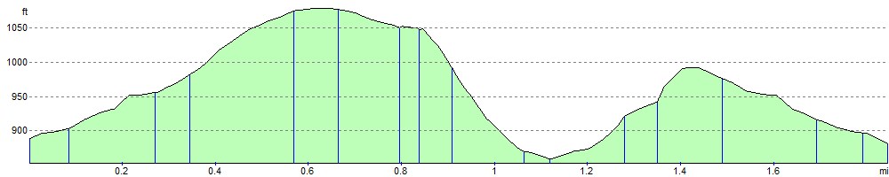
Elevation Profile