Daisy Nook Country Park
![]()
![]() Enjoy waterways, a lake, a canal, woodlands and wildflower meadows in this lovely country park in the Medlock Valley. The park is great for wildlife with great-spotted woodpeckers, owls, foxes and squirrels to look out for. The main highlights in the park are Crime Lake and the Hollinwood Branch Canal which was opened in the 1920s.
Enjoy waterways, a lake, a canal, woodlands and wildflower meadows in this lovely country park in the Medlock Valley. The park is great for wildlife with great-spotted woodpeckers, owls, foxes and squirrels to look out for. The main highlights in the park are Crime Lake and the Hollinwood Branch Canal which was opened in the 1920s.
There's also good facilities with a nice cafe and car park The park is very popular during the summer, with up to 30,000 visitors a month visiting the park, which stretches 18 miles from Bishops Park in Oldham to Paradise Wharf in Manchester.
The Medlock Valley Way long distance path runs through the park so it's easy to extend your outing. If you head west along the path you will soon come to Clayton Vale. Here you can enjoy a walk along the River Medlock or try one of the great mountain bike trails devised by the National Cycling Centre.
Following the path north will take you to Strinesdale Country Park where there's a nice circular trail around two pretty reservoirs.
Postcode
M35 9WJ - Please note: Postcode may be approximate for some rural locationsPlease click here for more information
Daisy Nook Country Park Ordnance Survey Map  - view and print off detailed OS map
Daisy Nook Country Park Open Street Map  - view and print off detailed map
Daisy Nook Country Park OS Map  - Mobile GPS OS Map with Location tracking
Daisy Nook Country Park Open Street Map  - Mobile GPS Map with Location tracking
Explore the Area with Google Street View 
Pubs/Cafes
The Café Riverside, as the name implies, is situated right alongside the river and includes a lovely sunny open terrace. Here you can to sit outside and enjoy the relaxing sounds of the water passing by (you might even see a kingfisher or heron if you keep your eyes open) as you take morning coffee and cakes. There's also a nice Garden Centre which include one of the largest, most varied selection of plants available in the Manchester area.
Dog Walking
The park is one of the best places in the area for a dog walk and you will probably see many other dog walkers on your outing.
Further Information and Other Local Ideas
Head a couple of miles west of the park and you can pick up the Rochdale Canal in Failsworth. Following it north will take you to Foxdenton Hall and Chadderton.
The long distance Tameside Trail passes through the park. The 30 mile circular walk explores several of the highlights of the River Tame Valley.
For more walking ideas in the area see the Greater Manchester Walks page.
Cycle Routes and Walking Routes Nearby
Photos
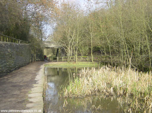
Crime Lake on the Hollinwood Branch Canal in Daisy Nook Country Park. Crime Lake was formed by the embankment that carried the Hollinwood Branch Canal across a small valley. It was a popular place of leisure in Victorian and Edwardian times. Today it forms part of Daisy Nook Country Park, between Ashton under Lyne and Oldham.
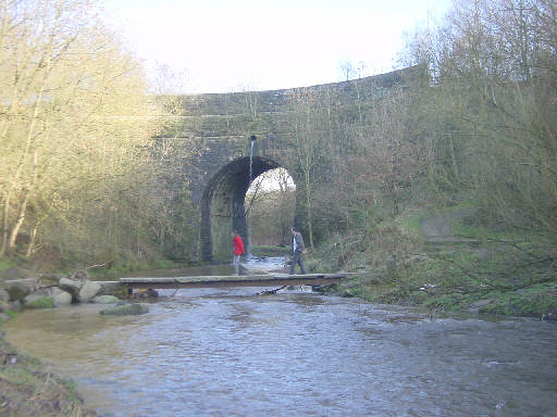
The former Waterhouses Tunnel at Daisy Nook Country Park. Waterhouses Tunnel (or Dark Tunnel or Boodle Tunnel) on the Hollinwood Branch Canal was opened out in the 1920s. It now forms part of Daisy Nook Country Park and carries a footpath and bridle way through the cutting.
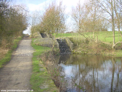
Lock staircase on the Hollinwood Branch Canal in the park. The remains of the disused Hollinwood Branch Canal pass through Daisy Nook Country Park between Ashton under Lyne and Oldham. There were four locks here (Waterhouses Locks) including this unusual lock staircase. More about the canal can be found at http:/www.hollinwoodcanal.co.uk


