Ecclesbourne Valley Way Railway Walk
![]()
![]() A fine railway themed walk through the Ecclesbourne Valley from Duffield to Wirksworth.
A fine railway themed walk through the Ecclesbourne Valley from Duffield to Wirksworth.
The walk runs along the River Ecclesbourne, following the route of the Ecclesbourne Valley Railway between the two stations. The finish point is Wirksworth station which is the headquarters of the splendid old heritage railway. The line is operated by a large fleet of heritage Diesel Multiple Units and some lovely old steam locomotives.
The walk starts at Duffield train station and picks up a trail along the river heading north west towards Windley. The route continues north past Turnditch, Hillclifflane, Idridgehay, Gibbet Wood and Gorseybank before arriving in Wirksworth. On the way you'll pass a number of the old stations dotted along the line. You can stop here for a rest and enjoy watching the trains come in and out of the stations. There's also some attractive countryside and riverside paths to enjoy in the valley.
Ecclesbourne Way Ordnance Survey Map  - view and print off detailed OS map
Ecclesbourne Way Open Street Map  - view and print off detailed map
Ecclesbourne Way OS Map  - Mobile GPS OS Map with Location tracking
Ecclesbourne Way Open Street Map  - Mobile GPS Map with Location tracking
Pubs/Cafes
On the route be sure to stop off at the excellent Bull Shed. The site includes the Shottle Farm Brewery and a pub located on a 60 acre working farm in the little village of Shottle. The farmhouse here dates back to 1793 with lots of animals to see such as Aberdeen Angus X Shorthorn cows, goats, pigs and a herd of black cats. The associated pub includes several original features with exposed stone walls, a sloping concrete floor with cocks foot prints and massive steel beams holding up the grain floor. It's full of character and has a cosy fire for colder days. They do delicious home cooked food and have an excellent selection of ales from their own brewery. You can find them at a postcode of DE56 2DT for your sat navs. The pub is also dog friendly if you have your canine friend with you.
Further Information and Other Local Ideas
Towards the end of the route around Ashleyhay and Wirksworth you could take a small detour to climb to Alport Heights. The viewpoint is a small climb to the east of the trail, offering fine views over the area.
At the end of the route there are lots of good options for extending the route around Wirksworth. You could enjoy a waterside stroll along the Cromford Canal and visit the historic Cromford Mill. At the other end of the route you could try the Walk around Belper, just to the north of Duffield.
For more walking ideas in the area see the Derbyshire Walks and Peak District Walks pages.
Cycle Routes and Walking Routes Nearby
Photos
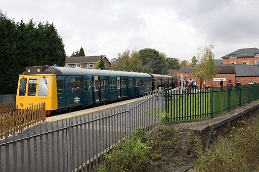
Duffield DMU on Ecclesbourne Valley Railway. DMU on Ecclesbourne Valley Railway at Duffield Station. The front coach is Class 117 Pressed Steel suburban unit no 51360.
Former Idridgehay station, 1998. View over the level-crossing on the ex-Midland branch from Duffield (to left) to Wirksworth (to right). The station was closed to passengers 16/6/47 when the regular branch service ceased, to goods 5/1/53. Although regular freight traffic to Wirksworth continued until 1/4/68, the line has survived and used for various purposes, having been operated since 2003 as the Ecclesbourne Valley Railway by WyvernRail plc (formed 1992). This explains the presence of the crossing-lights in 1998.


