Elidir Fawr Walk
![]()
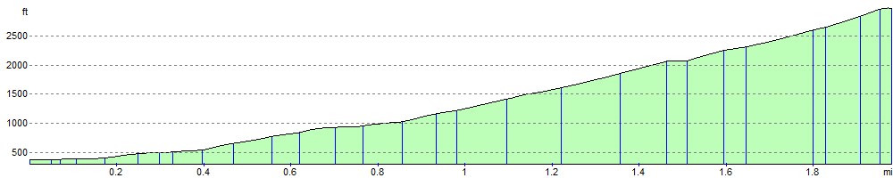
![]() Climb to Elidir Fawr, the northernmost peak in the Glyderau range on this challenging walk in Snowdonia. The walk takes you to the 924 metre (3,031 ft) summit from the village of Nant Peris at the bottom of the Llanberis Pass. It's only about a 2 mile climb, but quite steep.
Climb to Elidir Fawr, the northernmost peak in the Glyderau range on this challenging walk in Snowdonia. The walk takes you to the 924 metre (3,031 ft) summit from the village of Nant Peris at the bottom of the Llanberis Pass. It's only about a 2 mile climb, but quite steep.
The walk starts from the parking areas off the A4086 in Nant Peris. Cross the A4086 and then pick up a country lane heading north. A footpath then takes you the rest of the way to the summit, passing the Afon Dudodyn on the way. There are fabulous views over the peaks and reservoirs of the national park.
You can extend the walk by continuing a short way on to the pretty Marchlyn Mawr reservoir.
Following the path further will take you to Foel-Goch and then on to Y Garn. From the 947 m (3,107 ft) summit there are great views of Llyn Clyd and the Ogwen Valley.
Also nearby are the climbs to Glyder Fawr and Glyder Fach and Tryfan.
Postcode
LL55 4UF - Please note: Postcode may be approximate for some rural locationsElidir Fawr Ordnance Survey Map  - view and print off detailed OS map
Elidir Fawr Open Street Map  - view and print off detailed map
Elidir Fawr OS Map  - Mobile GPS OS Map with Location tracking
Elidir Fawr Open Street Map  - Mobile GPS Map with Location tracking
Further Information and Other Local Ideas
For an alternative circular walk from the Marchlyn Mawr Reservoir see the video below.
If you head north west from the car park you can enjoy a waterside walk along Llyn Peris.
Padarn Country Park is also nearby. You can pick up the Llanberis Lake Walk and the Dinorwic Quarry Walk here. The quarry is one of the significant sites on the Snowdonia Slate Trail which runs through the area. The circular long distance trail can be used to visit several of the other historic mining areas located in the World Heritage Site. Heading north along the trail would take you to Bethesda where you could visit the Penrhyn Quarry which was the largest slate quarry in the world during the 19th century. Heading south along the trail would take you to Dorothea Quarry where you'll find the remains of the old mining houses and a series of scenic lakes including Llyn Nantlle Uchaf.
For more walking ideas in the area see the Snowdonia Walks page.
Cycle Routes and Walking Routes Nearby
Photos

A dog poses on the summit ridge of Elidir Fawr. The rocky summit ridge of the mountain is capped by a cairn which has been adapted into a wind shelter.

Marchlyn Mawr from Elidir Fawr. Showing the Lake present in that square, and the scree slopes to the foreground. The Dam is in another square.

The Summit Cairn and Shelter. The highest point on Elidir Fawr [924m] is marked by a small cairn. A short distance east is a stone shelter. The mountains in the background are the Carneddau. Foel Goch intrudes into the picture [middleground, right].

Looking towards the summit

The Bwlch Melynwyn Gap on the summit ridge of Elidir Fawr. Y Tryfan and Glyder Fawr can be seen in the background.

Marchlyn Mawr Reservoir and the East Face.
Elevation Profile