Fairfield Horseshoe Walk
![]()
![]() This is a challenging horseshoe shaped walk which takes you on a tour of some of the Lake District's most beautiful fells. The walk begins at Ambleside and heads towards Rydal Mount, the historic home of William Wordsworth. You climb to Heron Pike and then onto Great Rigg and Fairfield before returning to Ambleside via Dove Crag, High Pike and Low Pike. The views are spectacular with Rydal Water, Grasmere , Lake Windermere and Coniston Water all visible from the peaks.
This is a challenging horseshoe shaped walk which takes you on a tour of some of the Lake District's most beautiful fells. The walk begins at Ambleside and heads towards Rydal Mount, the historic home of William Wordsworth. You climb to Heron Pike and then onto Great Rigg and Fairfield before returning to Ambleside via Dove Crag, High Pike and Low Pike. The views are spectacular with Rydal Water, Grasmere , Lake Windermere and Coniston Water all visible from the peaks.
This is an extremley challenging walk with an ascent of nearly three thousand feet. The paths are well defined however, care should be taken on the summit of Fairfield where in poor visibility there is the danger of steep drops to the north and west.
Fairfield Horseshoe Ordnance Survey Map  - view and print off detailed OS map
Fairfield Horseshoe Open Street Map  - view and print off detailed map
Fairfield Horseshoe OS Map  - Mobile GPS OS Map with Location tracking
Fairfield Horseshoe Open Street Map  - Mobile GPS Map with Location tracking
Pubs/Cafes
On the route you'll pass Rydal Hall where you could stop for refreshments at the tea rooms. There's lovely gardens here with a delightful outdoor seating area with views over a rushing waterfall.
Back in Ambleside there's the noteworthy Unicorn Inn. This quintessential traditional Lakeland public house is the oldest pub in Ambleside, dating back to the 18th century. They do good home cooked food and have a fine selection of ales. You can find the pub in the town at postcode LA22 9DT for your sat navs. The pub is also dog friendly if you have your four legged friend with you.
Photos

Nab Scar seen from near Rydal Cave. Nab Scar represents one end of the Fairfield Horseshoe.

On the Fairfield Horseshoe, South of Dove Crag. Taken at 11:34 on 4th January 2003, on a perfect winter's day, looking east towards the fells around Scandale Head and beyond.

Lord Crag, Fairfield Horseshoe. View looking north to the rocky outcrop of Lord Crag. Photograph taken from the Fairfield Horseshoe path as it climbs towards Heron Pike and beyond.

Col between Hart Crag and Fairfield on a snowy day in the mid winter of 2003. On this day an unseen wind was channelling up through this col and for a hundred metres or so a calm walk turned into something more akin to a Scottish mountain winter ridge until all returned to normal! Shot from across the Horseshoe south of Fairfield summit.

Descent to Rydal. The end of the Horseshoe. Ambleside and Windermere are further ahead.

Clouds over the hills on Heron Pike on the route.

Fell Runners on Great Rigg. Taken from NY355103, these fell runners complete the Horseshoe in well under 2 hours (some 11 miles and over 3000 foot of ascent).

Above High Pike on the Horseshoe
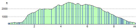
Elevation Profile