Fewston Reservoir Walk

 Enjoy an easy circular walk around the lovely Fewston Reservoir in the Yorkshire Dales. The path around the reservoir is well surfaced and largely flat so this is a good walk for abilities. The reservoir is surrounded by woodland and beautiful widlflowers including common vetch, betony, milkwork golden rod and common cow-wheat. Also look out for birds on the water including Moorhens, Geese and Ducks.
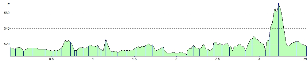
This walk starts at Blubberhouses at the northern end of the reservoir and follows the waterside footpaths around the reservoir. The circular trail runs for a distance of just over 3.5 miles so should take around 1-2 hours to complete.
It's easy to extend your walk by heading to the adjacent Thruscross Reservoir. A lovely footpath along the River Washburn will take you there. Swinsty Reservoir is also just to the south and also has an easy circular footpath.
Fewston Reservoir is located near to Leeds and Harrogate.
Fewston Reservoir Ordnance Survey Map  - view and print off detailed OS map
Fewston Reservoir Open Street Map  - view and print off detailed map
Fewston Reservoir OS Map  - Mobile GPS OS Map with Location tracking
Fewston Reservoir Open Street Map  - Mobile GPS Map with Location tracking
Explore the Area with Google Street View 
Pubs/Cafes
The Fewston Farm Shop is another nice place to visit in the area. Located just to the east of Fewston Reservoir the shop includes a cafe serving a large variety of teas and coffee and a selection of cakes and scones to accompany them. It's a lovely country spot with adjacent fields holding ponies and goats. You can find it just off the Skipton Road (A59) at a postcode of HG3 1SR.
Dog Walking
The reservoir is a great place for a dog walk and the tea room at the Washburn Valley Heritage Centre is also dog friendly with water bowls and treats provided in the outdoor seating area.
Further Information and Other Local Ideas
On the eastern side of Swinsty Reservoir you'll find the interesting Washburn Valley Heritage Centre. Inside there's informative exhibitions about the history and heritage of the Valley. This includes the history of Fewston Church from its 14th century tower and its rebuilding in 1697. There's also a series of information boards on the geology and natural landscape of the valley. The building includes a nice tea room where you can enjoy some refreshments after your exercise too.
Follow the Dales Way Link east and you will come to Beaver Dyke Reservoir and John O'Gaunt Reservoir. The photogenic ruins of John O'Gaunt Castle can also be found in this area.
Cycle Routes and Walking Routes Nearby
Photos

Yorkshire Blue skies over the dam at Fewston Reservoir in the Washburn Valley, north of Otley.

Fewston Reservoir in early winter. The reservoir was built in 1879 and has a capacity of about 3.5 million cubic metres. It is owned by Yorkshire Water, which manages it for the benefit of walkers, anglers and wildlife.

Spillway between Fewston and Swinsty reservoirs

Fewston Reservoir from the dam

Lush green vegetation at the western end of the site, near Blubberhouses.

A good view of the surfaced path.

Spillway at the eastern end of the lake near the dam and Swinsty Reservoir.

Cricket at Blubberhouses. A typical English village scene at the small settlement located the west of the site.
Elevation Profile