Glevum Way
![]()
![]() This circular walk takes you through the suburbs, countryside and villages around the city of Gloucester.
This circular walk takes you through the suburbs, countryside and villages around the city of Gloucester.
The walk starts at Gloucester's Victorian docks next to the Gloucester Waterways Museum which tells the story of England's canals and rivers. The walk then includes two consecutive waterside sections along the River Severn and the towpath of the Gloucester and Sharpness Canal, taking you to the village of Hardwicke.
From Hardwicke the path takes you through some delightful Gloucestershire countryside and the villages of Upton St Leonards, Hucclecote and Churchdown. The walk finishes by passing Gloucestershire Airport and the village of Walham, before returning to the Gloucester docks.
Glevum Way Ordnance Survey Map  - view and print off detailed OS map
Glevum Way Open Street Map  - view and print off detailed map
Glevum Way OS Map  - Mobile GPS OS Map with Location tracking
Glevum Way Open Street Map  - Mobile GPS Map with Location tracking
Cycle Routes and Walking Routes Nearby
Photos

Glevum Way, near Churchdown. The Glevum Way was devised by the Gloucester Ramblers Group as part of the Ramblers Association Diamond Jubilee celebrations dating it to 1995. The footpath itself is rather older and is shown on my 1980s vintage Landranger map. The fence at the right is to stop people sneaking into the Gloucestershire Airfield.

The Way is classified as a footpath. The building in the background is the office of a cattery and boarding kennel undertaking.

Canal side house, Hardwicke. This canal side house on the Gloucester and Sharpness Canal used to be the site of a bridge, there is a Bridge keeper's cottage on the opposite bank.

Hardwicke Church across the canal-side fields

St Leonard's Church, Upton St Leonards, nr Gloucester

Folland Avenue, Hucclecote, Gloucester. The traffic lights manage access onto the old Roman road, Ermin Way, now a minor road since the A417 was diverted around the north of Hucclecote some decades ago.

The River Severn at the White Horse. Walham. Looking downstream towards Gloucester, Bristol and the sea from the grounds of the once riverside pub, but now a Chinese restaurant.

Main Dock, Gloucester
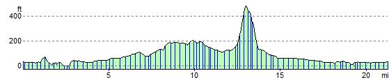
Elevation Profile