Grisedale Pike Walk
![]()
![]() Climb to this striking fell on this challenging walk near Keswick. The circular walk climbs to the summit of Grisedale Pike before visiting Hopegill Head and Sand Hill. It's a challenging walk but the path is mostly well defined.
Climb to this striking fell on this challenging walk near Keswick. The circular walk climbs to the summit of Grisedale Pike before visiting Hopegill Head and Sand Hill. It's a challenging walk but the path is mostly well defined.
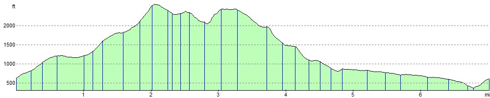
Start your walk from the car park on Whinlatter Pass just to the west of the village of Braithwaite. From here you can directly pick up the Grisedale Pike Path heading south west. The popular path climbs to the summit which stands at 791 m (2593 feet). From here there are wonderful views to the Cumbrian coast, the Vale of Keswick, the Pennines and the head of Derwentwater. On a very clear day you can even see the Belfast Hills and the Southern Uplands of Scotland.
The route then continues south west to Hopegill Head which stands at a height of 770 m (2,530 ft). The head includes the 130 metre (417ft) high cliff of Hobcarton Crag, which drops precipitously to Hobcarton Gill on the fell's north east side. From the summit the The Isle of Man is seen on clear days, as are the Scottish Border hills. To the east you can clearly see the Helvellyn range.
From Hopegill Head the walk descends to Sand Hill and Coledale Hause, before turning east towards the Force Crag Mines. The National Trust now own the area which was an important part of the Cumbrian mining industry. For over 200 years men worked the isolated spot digging for lead in the early years and then later barites and zinc.
The final section follows the Coledale Beck back to Braithwaite.
The village is located near to several other walking atttractions so there is great scope for extending your walk. Just to the north is the splendid Whinlatter Forest Park where there are miles of great walking paths and mountain bike trails. Just to the east you can pick up the Cumbria Way long distance trail and enjoy a walk along Derwent Water and a climb to Catbells.
Postcode
CA12 5TL - Please note: Postcode may be approximate for some rural locationsGrisedale Pike Ordnance Survey Map  - view and print off detailed OS map
Grisedale Pike Open Street Map  - view and print off detailed map
Grisedale Pike OS Map  - Mobile GPS OS Map with Location tracking
Grisedale Pike Open Street Map  - Mobile GPS Map with Location tracking
Further Information and Other Local Ideas
The pike is on the Coledale Horseshoe, a popular circular walk exploring the spectacular hanging valley. The longer route also starts from Braithwaite village and visits several of the other significant peaks in the area.
Just to the south of the Pike there's the old Force Crag Mine to explore. The Scheduled ancient monument dates back to the 1800s and is now run by the National Trust. It's an interesting place to visit with information boards detailing the mine's history and some pleasant walks along the Coledale Beck.
Cycle Routes and Walking Routes Nearby
Photos

Grisedale Pike viewed from the unnamed subsidiary peak above Hobcarton Crag.

Shelter, Grisedale Pike. Just under the summit looking towards Hopegill Head

Braithwaite from Station Road

Force Crag Mine

On Hopegill Head. Looking along the ridge to Ladyside Pike from the summit. The slabby crags in shot can be awkward in ice and snow.

On Sand Hill

Coledale beck.

The head of Coledale
Elevation Profile