High Hunsley Circuit
![]()
![]() Travel through the beautiful Yorkshire Wolds on this delightful circular walk.
Travel through the beautiful Yorkshire Wolds on this delightful circular walk.
The walk starts and ends in Brantingham Thorpe park and visits the villages of Walkington, Skidby, Brantingham, South Cave and Bishop Burton. The scenery is varied with sections through parkland, woodland and open countryside to enjoy.
Highlights on the route include the section through Risby Park near Beverley. The park includes the site of a medieval village and the remains of Risby Hall which was destroyed by fire in the 1780s. It also includes the lovely Folly Cafe which is a great place to stop for refreshments.
High Hunsley Circuit Ordnance Survey Map  - view and print off detailed OS map
High Hunsley Circuit Open Street Map  - view and print off detailed map
High Hunsley Circuit OS Map  - Mobile GPS OS Map with Location tracking
High Hunsley Circuit Open Street Map  - Mobile GPS Map with Location tracking
Pubs/Cafes
At Skidby you could stop off at the Millhouse. There's a fine restauarant here serving delicious modern British and European cuisine. It includes some beautifully landscaped gardens, located in the grounds of the 19th century Skidby Mill. Here you can sit outside and enjoy the barbecue/hog roast chalet and bar area. There's also a rooftop lounge with excellent views across the surrounding countryside. After your meal there's also the option of exploring the mill museum where you can learn all about the history of the area.
Cycle Routes and Walking Routes Nearby
Photos

High Hunsley Circuit, east-south-east of Brantingham, East Riding of Yorkshire. There are numerous dedicated walks made from the footpaths in the dales of Welton, Elloughton and Brantingham. At this point the circuit passes through a narrow strip of woodland (Lings Plantation) perched on the hill top, and joining together Elloughton and Welton Dales.

Part of the Circuit east north east of Sancton
High Hunsley Beacon

Skidby mill

North Plantation High Hunsley. The Wolds Way follows the course of Whin Lane, the minor road from South Newbald to Walkington, for a short distance. It crosses the North Newbald to Little Weighton road and then runs northeast under the shade of North Plantation until leaving Whin Lane and turning northwest once more.

Near Welton Dale, north east of Elloughton

Near Bishop Burton. The path leaves Rakes Road at this point, running along the right hand side of the hedge.

Yorkshire Wolds Way and the Circuit over the Yorkshire Wolds, east north east of Sancton. This track is common to both the Yorkshire Wolds Way and the Circuit, affording expansive views across the Wolds countryside.
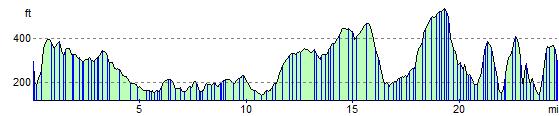
Elevation Profile