Hughenden Manor Walks
![]()
![]() The 1,500 acres of parkland surrounding the red brick Victorian mansion of Hughenden Manor is great for a short walk in lovely surroundings. There's woodland trails, pretty formal gardens and riverside paths to enjoy. The area is also surrounded by some beauitful Chilterns countryside.
The 1,500 acres of parkland surrounding the red brick Victorian mansion of Hughenden Manor is great for a short walk in lovely surroundings. There's woodland trails, pretty formal gardens and riverside paths to enjoy. The area is also surrounded by some beauitful Chilterns countryside.
The house and parkland is run by the National Trust so there are four good waymarked paths to try. There also beautiful formal gardens with an Italian influence, a walled garden, a willow maze and orchards.
Hughenden Manor was home to Prime Minister, Benjamin Disraeli during the 19th century. You can explore the house with its wonderful collection of personal memorabilia and Victorian playroom.
If you enjoy this walk then you could head to the nearby West Wycombe Park to extend your exercise.
Postcode
HP14 4LA - Please note: Postcode may be approximate for some rural locationsPlease click here for more information
Hughenden Manor Park Ordnance Survey Map  - view and print off detailed OS map
Hughenden Manor Park Open Street Map  - view and print off detailed map
*New* - Walks and Cycle Routes Near Me Map - Waymarked Routes and Mountain Bike Trails>>
Hughenden Manor Park OS Map  - Mobile GPS OS Map with Location tracking
Hughenden Manor Park Open Street Map  - Mobile GPS Map with Location tracking
Explore the Area with Google Street View 
Pubs/Cafes
There's a fine on site cafe selling a range of sandwiches and snacks.
Dog Walking
The park is a great place to bring your dog for a walk. Please keep them on a short lead around the estate.
Just to the west there's also Downley Common and Naphill common where there's some fine woodland trails for you and your pet.
Further Information and Other Local Ideas
Just to the north west there's the worthy village of Bradenham to visit. Here you'll find pretty cottages, a village green, a village pond, a cricket pitch and some fine woodland trails around the adjacent Bradenham Woods. The woods can be easily visited from Saunderton which has a train station.
For more walking ideas in the area see the Buckinghamshire Walks and Chilterns Walks pages.
Cycle Routes and Walking Routes Nearby
Photos
Hughenden Stream in the park Park. This remarkable little bridge carries all the public traffic to the Manor and Church over the stream. The house is the lodge to the Manor and the Church and from the year inscribed on one of the rainwater drainage hoppers appears to date from 1913.
A family sit and take in the view of this National Trust managed park. Hughenden Stream runs in the bottom of the valley along the near line of trees, while the A4128 road follows the far line.
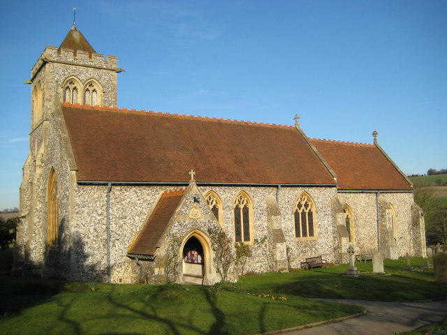
Church of St Michael and All Angels. Known as the Church in the Park because of its location in the grounds of the Manor, the church is unique insofar as it is the only one containing a memorial to a commoner (Benjamin Disraeli) erected by a monarch (Queen Victoria). The church was virtually completely rebuilt during the latter part of the nineteenth century.
Hughenden Church House. The Church House is a sixteenth century timber framed brick and flint building to the south-west of the church.


