Langdale to Keswick
![]()
![]() This is the third leg of the Cumbria Way taking you from Langdale to Keswick.
This is the third leg of the Cumbria Way taking you from Langdale to Keswick.
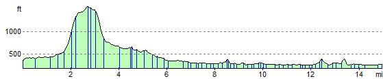
You start in Great Langdale following Mickleden Beck and Langstrath Beck to Rosthwaite with views of Bow Fell Mountain and Langdale Pikes on the way.
From Rosthwaite you follow the River Derwent past Castle Crag to the stunning Derwent Water where the shoreline path around the lake takes you into Keswick.
Langdale to Keswick Ordnance Survey Map  - view and print off detailed OS map
Langdale to Keswick Open Street Map  - view and print off detailed map
Langdale to Keswick OS Map  - Mobile GPS OS Map with Location tracking
Langdale to Keswick Open Street Map  - Mobile GPS Map with Location tracking
Pubs/Cafes
The Glaramara House hotel in Seatoller is in a stunning location, just south west of Rosthwaite. There's wonderful views of the Borrowdale Fells and nearby Glaramara from the lovely outdoor seating area in the spacious grounds. It's the perfect place to relax after a long walk on a warm day. Indoors there's a cosy resident’s lounge with a log fire and a spacious bar. They do very good food and also provide top quality accommodation if you need to stay over. You can find the hotel just to the east of the National trust car park on the Honister Pass at postcode CA12 5XQ.
Cycle Routes and Walking Routes Nearby
Elevation Profile