Lantern Pike
![]()
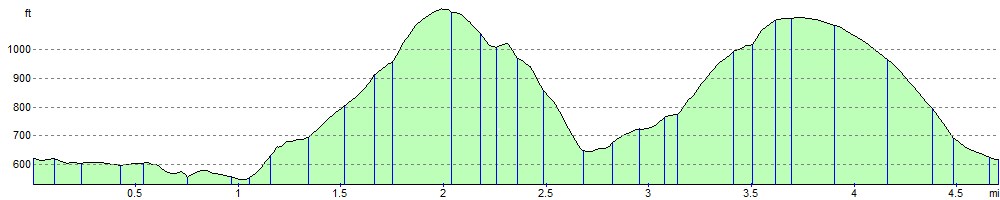
![]() This climb to Lantern Pike from Hayfield makes use of the Pennine Bridleway. It's a circular walk which starts in the village of Hayfield and takes you along the Sett Valley Trail to Birch Vale Reservoir. Here you turn north and climb to the 373 metres (1,224 ft) summit of the hill. At the summit you can take in some wonderful views of the surrounding Peak District hills and countryside. The walk then descends to the pretty hamlet of Little Hayfield before crossing Middle Moor and following the Snake Path back to Hayfield.
This climb to Lantern Pike from Hayfield makes use of the Pennine Bridleway. It's a circular walk which starts in the village of Hayfield and takes you along the Sett Valley Trail to Birch Vale Reservoir. Here you turn north and climb to the 373 metres (1,224 ft) summit of the hill. At the summit you can take in some wonderful views of the surrounding Peak District hills and countryside. The walk then descends to the pretty hamlet of Little Hayfield before crossing Middle Moor and following the Snake Path back to Hayfield.
If you would like to continue your walking in the area then a walk to Kinder Scout and Kinder Reservoir is a great option.
Lantern Pike Ordnance Survey Map  - view and print off detailed OS map
Lantern Pike Open Street Map  - view and print off detailed map
Lantern Pike OS Map  - Mobile GPS OS Map with Location tracking
Lantern Pike Open Street Map  - Mobile GPS Map with Location tracking
Pubs/Cafes
After your walk we recommend heading to the appropriately named Lantern Pike Inn in Hayfield. The interesting old pub dates from 1792, and has a very good menu. There's also a nice outdoor seating area where you can relax outside and enjoy views of the surrounding hills. You can find the pub in the village on 45 Glossop Rd, Little Hayfield with postcode SK222NG for your sat navs. The pub also does accommodation so you can stay over here if you need to.
Cycle Routes and Walking Routes Nearby
Photos

Moorland, Lantern Pike. The wall running across the photo marks the boundary of the National Trust property.

On the ridge, Lantern Pike. Footpath running along the ridge, with grouse moor either side. A killer for kids, because the monument and summit aren't at the highest point on the horizon. They are further off, only being seen once the "false summit" has been reached. Character building stuff.

Stile on Lantern Pike Looking NE along the flank of Lantern Pike, towards Little Hayfield.

Bridleway up Lantern Pike This work was done in an attempt to prevent erosion. A camber was added together with a wide stone drain to improve drainage.

Toposcope, Lantern Pike

Cyclist on the pike. This is where the National Trail crosses the shoulder of Lantern Pike at an elevation of 340 metres. It's been a bit of a pull from the road at Birch Vale a mile to the southwest.

East from Lantern Pike. Little Hayfield, Middle Moor and Kinder Scout.

Lantern Pike from Middle Moor. A nice overview of the Pike and the Sett Valley.
Elevation Profile