Liberty Trail

 Follow in the footsteps of the villagers that made their way to join the Protestant Monmouth Rebellion in 1685.
The route starts at Ham Hill Country Park where you will find splendid views of the Mendip Hills, Blackdown Hills, Quantock Hills and Dorset Downs. From here you head south through West Chinnock, Haselbury Plucknett, Misterton and Wayford Woods before coming to Forde Abbey. This former Cistercian monastery has 30 acres of award winning gardens and is well worth a look. Also of interest is Cricket St Thomas - it's just to the north of the trail and has 160 acres of parkland and gardens to explore.
The route continues towards Thorncombe and then onto Fishpond Bottom via Lambert's Castle Iron Age hill fort. The final stretch takes you past Wooton Fitzpaine and then along the River Lim to Lyme Regis on the coast.
Liberty Trail Ordnance Survey Map  - view and print off detailed OS map
Liberty Trail Open Street Map  - view and print off detailed map
Liberty Trail OS Map  - Mobile GPS OS Map with Location tracking
Liberty Trail Open Street Map  - Mobile GPS Map with Location tracking
Pubs/Cafes
Next to Ham Hill you'll find the excellent Prince of Wales. The pub is located right next to the hill and includes a lovely beer garden with fine views over the surrounding countryside. In the summer months there is live music in Amy’s garden, an ice cream hut, pizza oven and an outside bar. You can find the pub next to the hill with a postcode of TA14 6RW for your sat navs.
In Misterton there's the Grade II listed Globe Inn to consider. The classic stone pub dates to the 17th century and has a good selection of ales. You can find them on Middle Street at postcode TA18 8LX. It's located very close to Crewkerne train station so if you are starting or finishing a walk from there it's a nice option.
Just north of the village there's also the Crooked Swan. The 18th century coaching inn has a fine interior with exposed steel beams, open fire and cosy nooks and crannies. Outside there's a lovely garden area to relax in on warmer days. They serve excellent food and can be found on Church Street at postcode TA18 7HR for your sat navs.
Further Information and Other Local Ideas
Around Uplyme the trail links with the East Devon Way and the Wessex Ridgeway. These waymarked long distance trails provide a further opportunity for exploring the area.
For more walking ideas in the area see the Somerset Walks and Dorset Walks pages.
Cycle Routes and Walking Routes Nearby
Photos

Farmland near West Chinnock. A tractor works on a field on the slopes of West Chinnock Hill. Doubtless they would have continued across this slope, but have been removed. Out of sight in the dip, following the line of trees, is Broad River. Seen from footpath Y11/8, here followed by both the Monarch's Way and the Liberty Trail.

Public Footpath to Uplyme East Devon Way, Wessex Ridgeway and Liberty Trail leave Lyme Regis

Footpath to Uplyme Mill. Looking towards the point where the routes of the East Devon Way, Wessex Ridgeway and Liberty Trail diverge. The East Devon Way continues towards Uplyme and the other routes proceed in the direction of Rhode Barton.

View of the front of Forde Abbey. The Abbey was originally a Cistercian monastery in the twelfth century. During the dissolution of the monasteries Richard Pollard acquired the property and later in 1649 it was bought by Edmund Prideaux, Attorney General to Cromwell. He converted the building and made it into a house. It is still in private ownership and open to the public. Today there was a wedding and one can just about see the guests enjoying the sunshine on the lawn outside the house.

Ham Hill War Memorial. The country park is the start point for the route. It is located in the village of Stoke Sub Hamdon, just east of Yeovil.

Middle Mill Farm. Middle Mill Farm on the Dorset/Devon border along the Liberty trail.

Headwater valleys of the Blackwater. The view looks across the valleys of some half a dozen streams collecting to form the Blackwater River. Seen from a field crossed by Hawkchurch Footpath 5, here followed by the Liberty Trail and the Wessex Ridgeway path. In the background rises Payne's Down.

The River Lim Near Middle Mill Farm, from a foot bridge forming part of the Wessex Ridgeway and Liberty Trail. The river is about 3 miles in length, flowing through the Devon-Dorset border. It rises from multiple springs at Raymond's Hill, near the village of Uplyme in East Devon, and flows southeasterly through Dorset, into the English Channel via Lyme Bay in the town of Lyme Regis, Dorset. The river falls over 200 metres from its source.
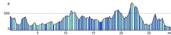
Elevation Profile