Walks Near Liskeard
![]()
![]() This interesting market town is located in the south eastern part of Cornwall. It's one of the oldest towns in the county and worth exploring for its historical interest. For walkers there's numerous trails to try to the north west of the town on Bodmin Moor.
This interesting market town is located in the south eastern part of Cornwall. It's one of the oldest towns in the county and worth exploring for its historical interest. For walkers there's numerous trails to try to the north west of the town on Bodmin Moor.
This short walk takes you around the town centre visiting Castle Park and some of the other highlights in the town. These include the 15th century church and the 17th century Stuart House where Charles I stayed in 1644, when his forces were chasing the Parliamentarians.
Postcode
PL14 6AB - Please note: Postcode may be approximate for some rural locationsPlease click here for more information
Liskeard Ordnance Survey Map  - view and print off detailed OS map
Liskeard Open Street Map  - view and print off detailed map
*New* - Walks and Cycle Routes Near Me Map - Waymarked Routes and Mountain Bike Trails>>
Liskeard OS Map  - Mobile GPS OS Map with Location tracking
Liskeard Open Street Map  - Mobile GPS Map with Location tracking
Walks near Liskeard
- Copper Trail - Visit some of the most beautiful parts of Bodmin moor on this circular route which takes you on a tour of the historic Cornish Copper mines
- Siblyback Lake - Enjoy a walk or cycle on the new waterside path around this beautiful lake and country park in Cornwall
- Golitha Falls - Golitha Falls National Nature Reserve has woodland walking trails taking you through a steep-sided valley gorge
- Colliford Lake - Enjoy a lovely waterside walk along the shore of this large lake on Bodmin Moor
- Minions Cheesewring - This circular walk visits the Cheesewring granite tor and the Hurlers stone circle from the Cornish village of Minions.
- Brown Willy - Climb to the highest point on Bodmin Moor on this circular walk in north east Cornwall
- Rough Tor - This is a climb to the 1313 ft (400m) summit of Rough Tor on Bodmin Moor
- Dozmary Pool - Visit the mysterious waters of the Dozmary Pool on this easy walk on Bodmin Moor.
You can park at the car park at the southern end of Colliford Lake to start your walk - Callington - This Cornish town has some fine local hill climbs and riverside walks to try
- Kit Hill - This country park in Cornwall covers 400 acres with miles of good footpaths to try
Pubs/Cafes
The King Doniert is a good value pub in the town centre. There's a decent menu and a terrace area with nice views of the town. The pub is named after King Doniert whose seat was in the ancient town. The Doniert Stone, three miles to the north, commemorates the king, who drowned in around AD875. The historic monument is managed and protected by the Cornwall Heritage Trust, which describes Doniert as ‘the last-known independent king of Cornwall’, before the kingdom fell under Saxon control. You can find them on Barras Street with postcode PL14 6AB for your sat navs.
Further Information and Other Local Ideas
Head north of the town and you can pick up the Copper Trail and visit Siblyback Lake. Near here there's also the village of Minions where you can visit the Cheesewring granite tor and the Hurlers ancient stone circle. From the car park here you can also pick up the Liskeard and Caradon Railway Walk which takes you along the old railway constructed to transport copper and tin ores, as well as granite, from Caradon Hill to Moorswater. The trail also has a section suitable for cyclists.
The popular Golitha Falls are just south of Siblyback. There's a lovely wooded trail and rushing falls in this splendid nature reserve.
Head east to neighbouring Callington and you could enjoy climbs to the ancient hill fort at Cadson Bury and the country park at Kit Hill.
For more walking ideas in the area see the Bodmin Moor Walks page.
Photos
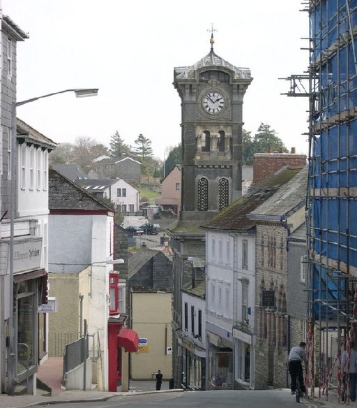
Town centre. The town is built at the head of a steep valley and spreads out onto the plateau above. This photograph looks east across the town centre valley. The Guildhall Clocktower rises above the level of the surrounding buildings.
Liskeard Pipewell. This is not really a well but a spring which has been built around and the water channelled through pipes. It is in a back lane in Liskeard town centre appropriately called 'Well Lane'. The well surrounds date mostly from the early 19th century, although records of this well go back to the 14th century. A notice next to the well tells us that the water is said to possess healing virtues and lucky effects in matrimony. Another notice warns sternly that the water is unfit to drink!
Moorswater Viaduct to the west of the town near the East Looe River. Distance view of the mainline railway viaduct taken from north of Dobwalls. The viaduct was built alongside the Cornwall Railway's original stone pillar and wooden trestle viaduct. Some of the stone pillars are still standing. The construction of the dual carriageway for the Liskeard by-pass can be seen in this 1981 photograph, middle distance on the left.


