Llantrisant Walks
![]()
![]() This Welsh town has some nice trails though the Ely Valley and some fine local hill climbs to try. It's located in the county of Rhondda Cynon Taf, on the River Ely and the Afon Clun. Llantrisant is also notable as being the home of the Royal Mint, a government-owned mint that produces coins for the United Kingdom.
This Welsh town has some nice trails though the Ely Valley and some fine local hill climbs to try. It's located in the county of Rhondda Cynon Taf, on the River Ely and the Afon Clun. Llantrisant is also notable as being the home of the Royal Mint, a government-owned mint that produces coins for the United Kingdom.
This walk from the town follows the waymarked Glamorgan Ridgeway Walk walk to Llantrisant Forest, Mynydd Garth Maelwg and Mynydd Meiros to the west. There's some nice peaceful woodland trails, river crossings and splendid views from the high points on the ridge.
The walk starts in the town and follows the Ffordd Bryniau and Glamorgan Ridgeway walk west past Talbot Green and the River Ely and into Llantrisant Forest. The trail then heads up to Mynydd Meiros where there are some excellent views over the surrounding hills and countryside. The route then turns around to follow alternative paths through the forest.
Llantrisant Ordnance Survey Map  - view and print off detailed OS map
Llantrisant Open Street Map  - view and print off detailed map
Llantrisant OS Map  - Mobile GPS OS Map with Location tracking
Llantrisant Open Street Map  - Mobile GPS Map with Location tracking
Walks near Llantrisant
- Taff Ely Ridgeway Walk - Follow the Taff Ely Ridgeway Walk/Ffordd y Bryniau through the Ely Valley and Taff Vale on this walk in South Wales
- Glamorgan Ridgeway Walk - Follow the Glamorgan Ridgeway from Margam Country Park, near Port Talbot, through beautiful upland and valley scenery, to Caerphilly Castle
- Caerphilly Mountain - Enjoy a climb to the summit of Caerphilly Mountain and a walk across Caerphilly Common on this circular route in South Wales.
You can park at the Caerphilly Mountain Snack Bar car park on Mountain Road to start your walk - Garth Hill - This challenging walk takes you to the summit of Garth Hill or Mountain near Cardiff
- Castle Coch - Visit this 19th-century Gothic Revival in Tongwynlais and enjoy a walk or cycle in the adjacent Fforest Fawr
- Fforest Fawr - This large area of woodland has some lovely waymarked footpaths including the delightful Fforest Fawr sculpture trail
- Cardiff - Cardiff has some fine walks along the coast and great riverside trails along the River Taff
- Rudry - This little village is located just east of Caerphilly in the beautiful Rhymney Valley
- Brombil Reservoir - This walk visits Brombil Reservoir and Brombil Woods near Port Talbot.
- Penrhys Pilgrimage - This long distance walk runs from Llandaff in Cardiff to the village of Penrhys in Rhondda Cynon Taf.
Pubs/Cafes
Head to the Cross Inn for some post walk refreshment. The friendly pub serves good food and can be found at postcode CF72 8AZ.
Dog Walking
The woods and hills make for a fine dog walk and the Cross Inn mentioned above is also dog friendly.
Further Information and Other Local Ideas
Head to the Llantrisant Guildhall Heritage & Visitors Centre to find out more about the remarkable history of the town, stretching back more than 1,500 years. The restored 14th century Grade II Listed Building re-opened following National Lottery Heritage Fund support in 2019. To celebrate the history of the building, its Freemen and the town, the film below was produced by Calan Films. It plays in the Llantrisant Guildhall every day for its many visitors and can be bought as a DVD.
The Taff Ely Ridgeway Walk also runs through the town. You could follow it east to visit Garth Hill and the popular Caerphilly Mountain. Near here there's also Castle Coch and the expansive Fforest Fawr near to Cardiff.
The long distance Penrhys Pilgrimage also passes through the town on its way to the historic village of Penrhys or to the 12th century Llandaff Cathedral in Cardiff.
Photos
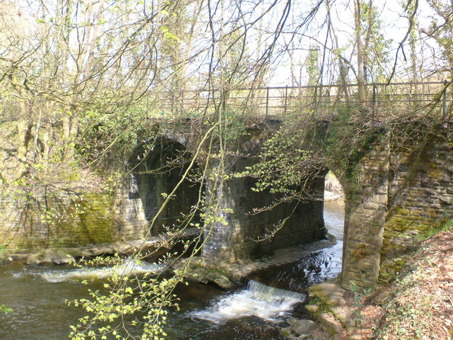
Disused railway bridge across river Ely. This bridge is on the confluence of the river Ely and Nant Muchudd, and was the principal railway line up the Ely valley towards tonyrefail
Statue of Dr William Price in the town. Price was a Welsh doctor known for his support of Welsh nationalism, Chartism and his involvement with the Neo-Druidic religious movement. He has been recognized as one of the most significant figures of 19th-century Wales, and one of the most unusual in Victorian Britain.
View across the fields towards Llantrisant Old Church. This Grade II building was declared redundant in 1899 when Llantrisant New Church was built some two kilometres down the road. Both churches are dedicated to SS Afran, Ieuan and Sannan. The old church, which dates from the medieval period, is now under the care of the Friends of Friendless Churches Society. There is a holy well by the gate.


