Mount Keen
![]()
![]() This is the shortest route to the summit of Mount Keen, the most easterly of the Scottish Munros. It starts at the Invermark car park in Glen Esk and heads through Glen Mark to the summit. The path is quite good for most of the route but become rockier towards the summit. There are fabulous views of Glen Esk, Loch Lee and the Cairngorms. Look out for red deer as you make your way through the beautiful Glen Mark.
This is the shortest route to the summit of Mount Keen, the most easterly of the Scottish Munros. It starts at the Invermark car park in Glen Esk and heads through Glen Mark to the summit. The path is quite good for most of the route but become rockier towards the summit. There are fabulous views of Glen Esk, Loch Lee and the Cairngorms. Look out for red deer as you make your way through the beautiful Glen Mark.
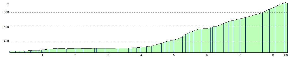
Mount Keen stands at 939 m (3,081 feet). The walk will probably take about 5-7 hours.
Postcode
DD9 7YZ - Please note: Postcode may be approximate for some rural locationsMount Keen Ordnance Survey Map  - view and print off detailed OS map
Mount Keen Open Street Map  - view and print off detailed map
Mount Keen OS Map  - Mobile GPS OS Map with Location tracking
Mount Keen Open Street Map  - Mobile GPS Map with Location tracking
Further Information and Other Local Ideas
Head west from the start point and you can try the Loch Lee Walk where you can enjoy a waterside walk along the loch and visit the Falls of Unich and the Falls of Damff.
To continue your walking in Glen Esk head a few miles south east and try the popular Edzell Blue Door Walk. This takes you along a splendid river gorge on the North Esk with waterfalls and salmon leaps to see on the way.
Head north to Ballater and you could pick up the popular 7 Bridges Walk.
Photos

Trig point, Mount Keen. The fairly uniformly rounded Mount Keen ends in a little rocky outcrop holding the summit trig point.

Mount Keen path. Path leading to the summit of Scotland's most easterly Munro. Without a properly constructed path the walker's route to a polular hill like this would quickly turn into a wide strip of eroded moorland.

Looking down Glen Mark from Couternach. The Glen Mark track and Mounth path were like an ice rink, the planned ascent of Mount Keen was abandoned. Couternach's slopes made for slow progress through deep snow.

Water of Mark. View towards the Gilfumman cliff face, over the Cowiehillocks Plantation and the Water of Mark.

Queen's Well. Beneath the granite arms of the well (reflected here in the water) lies a spring of exceptionally clear water.

The Mounth path from Glen Esk to Ballater. Junction where the path leaves the land rover track at 670m. Path forks further on with the more frequently used right branch leading to Mount Keen in the background.

Couternach. A small but prominent hill above Glenmark. The distinctive hill at the left of the picture is Craig of Doune.
_-_geograph.org.uk_-_1621750.jpg)
Invermark Castle (remains of)
Elevation Profile