Penistone Boundary Walk
![]()
![]() Explore the countryside around Penistone and enjoy fabulous views of the Pennine Hills on this circular walk.
Explore the countryside around Penistone and enjoy fabulous views of the Pennine Hills on this circular walk.
The walk passes famland and woodland and also includes a lovely stretch around Scout Dike and Royd Moor Reservoirs just to the north of Penistone. You will also enjoy views of the River Don crossing it a couple of times on the route.
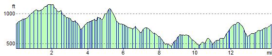
The trail runs for just under 15 miles and includes some moderate hill climbs on the way.
Penistone Boundary Walk Ordnance Survey Map  - view and print off detailed OS map
Penistone Boundary Walk Open Street Map  - view and print off detailed map
Penistone Boundary Walk OS Map  - Mobile GPS OS Map with Location tracking
Penistone Boundary Walk Open Street Map  - Mobile GPS Map with Location tracking
Cycle Routes and Walking Routes Nearby
Photos

Part of the Penistone Boundary Walk pointing in the Gunthwaite direction. Looking back towards Cross Lane and Hoylandswaine.

Scout Dike Reservoir Pic took from the car park, Royd Moor wind turbines can be seen off centre right on skyline.

Royd Moor Reservoir. A spring time view across the meadows of Royd Moor Farm from Royd Moor Road. Ingbirchworth village is in the distance on the left, with the white building of the former Rose and Crown pub, the last house in the village (going south) visible.

The dam at Gunthwaite Dam. Now a fishing pond for (I think) Cawthorne fishing club. The dam originally provided the head of water to feed the smaller pond by the mill building.

Conversion of the mill at Gunthwaite. Gunthwaite Mill has been part of the Bosville Estate (Gunthwaite Hall) since Medieval times and ceased gringing corn for farmers in 1956. It has recently been converted to residential housing.

Heron in the trees above Gunthwaite Dam
Elevation Profile