Purbeck Way
![]()
![]() This beautiful walk takes you from Wareham to Swanage giving splendid views of the Purbeck Hills and the Dorset coast. The route below uses the South West Cost path and the Purbeck Way to create a super circuit of the area.
This beautiful walk takes you from Wareham to Swanage giving splendid views of the Purbeck Hills and the Dorset coast. The route below uses the South West Cost path and the Purbeck Way to create a super circuit of the area.
The route starts with a lovely waterside stretch along the River Frome from Wareham. You then enter Stoborough Heath where you will pass the Blue Pool - a flooded, disused clay pit. Shortly after you arrive at the pretty village of Corfe Castle with its ruined 10th century castle of the same name. The path then leads you through Corfe Common and onto the stunning Dorset coast where you join the South West Coast Path. The coastal section then takes you past the beautiful Chapman's Pool, through Durlston Country Park to Swanage. From Swanage you continue to Ballard Down where you join the Purbeck Way, crossing the Purbeck Hills to return to Corfe Castle.
The video below left shows the splendid view as you cross the Purbeck Hills from Ballard Down to Corfe Castle. On your right you can see Poole Harbour and Bournemouth, while on your left is Swanage and the Purbeck Hills. On a clear day the Isle of Wight is also clearly visible.
Please click here for more information
Purbeck Way Ordnance Survey Map  - view and print off detailed OS map
Purbeck Way Open Street Map  - view and print off detailed map
Purbeck Way OS Map  - Mobile GPS OS Map with Location tracking
Purbeck Way Open Street Map  - Mobile GPS Map with Location tracking
Cycle Routes and Walking Routes Nearby
Photos

The Purbeck Way leaves Coombe Keynes but has to strike north east to avoid the military ranges.

Jogger on the Purbeck Way. The track descends Godlingston Hill on its south side. The green mound in the middle distance is Round Down, with the western end of Ballard Down beyond that. The jogger was the only person to pass me on the Nine Barrow Down section of the Purbeck Way - once going in the opposite direction, then here going in the same direction as me.

The trail passes across Ailwood Down, near Woolgarston

On the trail near to Harman's Cross. On open heathland, looking towards Corfe.

Milestone on the trail. A bridleway approaches from the left then crosses the Purbeck Way bridleway along the chalk ridge top and descends through King's Wood on the far side of the gate in the hedge. The milestone says that it is 2.5 miles to Corfe Castle.

A group of three walkers with backbacks on a glorious day in the summer of 2006. This bridleway descends from the B3069 road towards Corfe Common and the village of Corfe Castle. The ruins of the castle itself are clearly visible in the gap in the chalk ridge.

Sign on the path. To the left of the sign there is a tumulus. Swanworth Quarry in the distance is being returned to nature.

Lots of yellow gorse flowers on the descent to Corfe
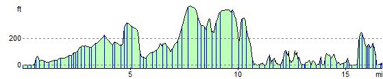
Elevation Profile