Ridge and Valley Walk
12 miles (19 km)

 Follow the valley of the River Dart on this lovely walk through Devon.
The walk starts at Eggesford Barton near the train station and heads towards Chawleigh and then Leigh Bridge where you join the river. The route continues to West and East Worlington before finishing at Witheridge.
There is a 3 mile link section from Chulmleigh to Eggesford at the western end of the route. Here you can explore Eggesford Forest with its Douglas Fir trees, pretty streams, ancient motte and bailey castle and lots of interesting flora and fauna.
Ridge and Valley Walk Ordnance Survey Map  - view and print off detailed OS map
Ridge and Valley Walk Open Street Map  - view and print off detailed map
Ridge and Valley Walk OS Map  - Mobile GPS OS Map with Location tracking
Ridge and Valley Walk Open Street Map  - Mobile GPS Map with Location tracking
Cycle Routes and Walking Routes Nearby
Photos

Field beside the B3042. This field to the south of Great Burridge is crossed by the Ridge and Valley Walk.

Old farm building near Sowden's Burridge. Old farm building in the corner of a field beside the trail.

Footbridge over the Little Dart River. The Little Dart River flows through a valley to the south of Chulmleigh, here the trail crosses the river via this footbridge.

Lych gate, Chawleigh, Devon

View of West Worlington

St John The Baptist Church, Witheridge, in 1993
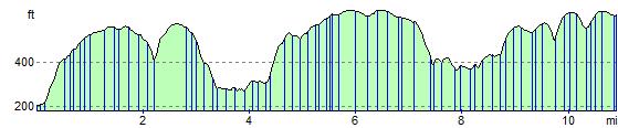
Elevation Profile