Ridge Walk Mam Tor to Lose Hill
![]()
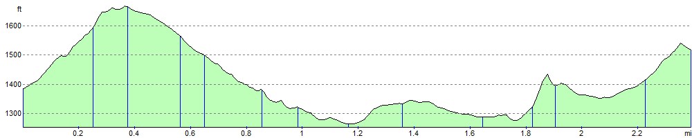
![]() Follow the Great Ridge from Mam Tor to Lose Hill on one of the most popular walks in the Peak District. Although the walk reaches a height of well over 1600ft, it is not as challenging as you might think because the start point for walk is already in an elevated position. The walk runs for a distance of about 2.5 miles, so roughly 5 miles there and back.
Follow the Great Ridge from Mam Tor to Lose Hill on one of the most popular walks in the Peak District. Although the walk reaches a height of well over 1600ft, it is not as challenging as you might think because the start point for walk is already in an elevated position. The walk runs for a distance of about 2.5 miles, so roughly 5 miles there and back.
It's a very beautiful area with the views over the Peak District stunning for the duration of the route. You can see the Hope Valley, the Edale Valley and several of the prominent fells. The area is also geologically fascintating with several 320 million year old Carboniferous rocks.
Start the walk from the National Trust Mam Nick car park. It's located just to the south west of Mam Tor on the Sparrowpit Buxton A623.A6 Road. From here it's a short but steep climb to the 517m (1,696 ft) summit of Mam Tor. The route then passes along the Great Ridge, descending to Hollins Cross before passing Back Tor and finishing on Lose Hill. It's about a 2.5 mile walk so 5 miles in total.
This ridge walk is located very close to both Edale and Castleton so you could start your walk from either of these popular Peak District villages.
To extend your walk you can visit the nearby Winnats Pass with its towering limestone pinnacles. You could also pick up the Pennine Way around Edale and climb towards Kinder Scout.
If you head west from the car park you can climb across Rushup Edge and visit Lord's Seat at 550 m (1,804 ft).
Postcode
S33 8WA - Please note: Postcode may be approximate for some rural locationsRidge Walk Mam Tor to Lose Hill Ordnance Survey Map  - view and print off detailed OS map
Ridge Walk Mam Tor to Lose Hill Open Street Map  - view and print off detailed map
*New* - Walks and Cycle Routes Near Me Map - Waymarked Routes and Mountain Bike Trails>>
Ridge Walk Mam Tor to Lose Hill OS Map  - Mobile GPS OS Map with Location tracking
Ridge Walk Mam Tor to Lose Hill Open Street Map  - Mobile GPS Map with Location tracking
Explore the Area with Google Street View 
Cycle Routes and Walking Routes Nearby
Photos
.jpg)
Ramblers on the Mam Tor Ridge

The ridge path between Mam Tor and Lose Hill

Ridge path to Mam Tor from Hollins Cross

South Ridge, Lose Hill

Lose Hill. The eastern end of a superb ridge that stretches to Mam Tor - separating the Noe Valley from the Hope Valley. Photo shows the National Trust's Losehill Pike and Ward's Piece sign.

North ridge on Lose Hill

Ridge path to Back Tor and Lose Hill

Footpath to Hollins Cross
Elevation Profile