Rockford and Ibsley Common
![]()
![]() This circular walk explores the Rockford and Ibsley Commons in the New Forest. On the expansive commons you'll find miles of footpaths taking you to attractive heathland and woodland. The commons are also in an elevated position so there are fine views over the surrounding areas from the high points. Look out for grazing ponies and some pretty babbling brooks as you go.
This circular walk explores the Rockford and Ibsley Commons in the New Forest. On the expansive commons you'll find miles of footpaths taking you to attractive heathland and woodland. The commons are also in an elevated position so there are fine views over the surrounding areas from the high points. Look out for grazing ponies and some pretty babbling brooks as you go.
You can start the walk from the car park just to the east of Rockford Green and Blashford Lakes. From here you can pick up footpaths heading east to the Appleslade Inclosure and Red Shoot Wood.
You then follow nice trails along the Linford Brook in the Great Linford Inclosure. The final section takes you past Bigsburn Hill before returning to the car park.
To continue your walk simply head east from the car park to visit the splendid Blashford Lakes. There's lovely trails around the nature reserve where there's lots of water loving wildlife to look out for. You can also pick up the long distance Avon Valley Path there and try our Fordingbridge River Walk along the River Avon from Ibsley to Fordingbridge.
Rockford and Ibsley Common Ordnance Survey Map  - view and print off detailed OS map
Rockford and Ibsley Common Open Street Map  - view and print off detailed map
Rockford and Ibsley Common OS Map  - Mobile GPS OS Map with Location tracking
Rockford and Ibsley Common Open Street Map  - Mobile GPS Map with Location tracking
Further Information and Other Local Ideas
Just to the north west is the nearby town of Verwood. Here you can enjoy a walk around Verwood Forest, the Cranborne Common Nature Reserve and the Stephen's Castle Nature Reserve where there's a lovely viewpoint.
Cycle Routes and Walking Routes Nearby
Photos
Rockford Common in the 1960's was subjected to gravel extraction which lowered the level of the common by about 6 metres. The area has been owned by the National Trust since 1999. The common has become increasingly overgrown due to high grazing pressures.
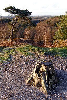
Stump, Rockford Common, New Forest. This tree stump is above the large disused sandpit on the western end of Rockford Common. Good views across the Avon valley from here.
Pony grazing beneath pines on Rockford Common, New Forest Late afternoon on a mild winter's day - this commoner's pony is grazing in the shade of these pines in the northern part of Rockford Common.
Ibsley from Ibsley Common. Looking across the Avon valley from the edge of the high ground on Ibsley Common. In the foreground are farm buildings at Mockbeggar. The line of houses across the middle is Ibsley village. Many of the fields and farms between the village and common are used for equestrian purposes.


