Scafell Pike from Langdale

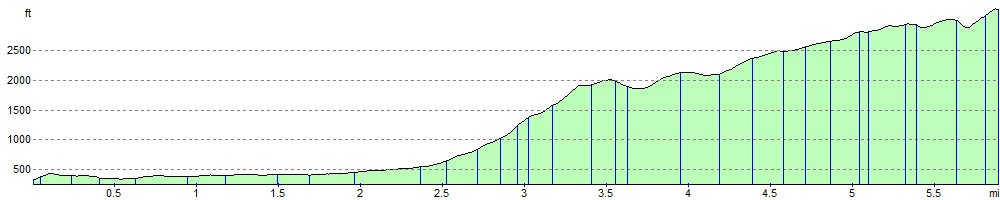
 This is one of the longer and more challenging routes to the top of England's highest mountain. There's several challenging sections with steep scrambles so this route is only really suitable for more experienced hikers. Along the way you are rewarded with spectacular views of the Langdale Valley and Langdale Pikes.
The walk starts from the New Dungeon Ghyll Hotel in Langdale, following a section of the Cumbria Way along Langdale Fell and Mickleden Beck, to Angle Tarn. This section also passes the beautiful Rossett Gill waterfall.
From the tarn you continue past Esk Hause to Ill Crag, before the final section takes you onto the Scafell Summit. Please note that a fair amount of scrambling is required from Esk Hause to the Scafell summit. From here views are stunning with the coast, the Isle of Man and Snowdonia all visible on a clear day.
Look out for birds of prey including buzzards and kestrels as you make your way along the route.
For an alternative route to the summit you can try the Scafell Pike from Borrowdale walk. This route takes you around Styhead Tarn and along the famous Corridor Route.
For the most direct route to the summit try the Scafell Pike From Wasdale walk.
To extend your walking in the area you can climb to the Langdale Pikes. The route also starts from New Dungeon Ghyll.
The climbs to Crinkle Crags, Bowfell and Dungeon Ghyll are also nearby.
Scafell Pike from Langdale Ordnance Survey Map  - view and print off detailed OS map
Scafell Pike from Langdale Open Street Map  - view and print off detailed map
Scafell Pike from Langdale OS Map  - Mobile GPS OS Map with Location tracking
Scafell Pike from Langdale Open Street Map  - Mobile GPS Map with Location tracking
Cycle Routes and Walking Routes Nearby
Photos

Dungeon Ghyll

New Dungeon Ghyll Hotel

Cumbria Way

Langdale Mountains

Rossett Gill

Above Rossett Pike

Esk Hause

Scafell Pike Plateau
Elevation Profile