Shropshire Way
![]()
![]() This walk takes you through some of the most beautiful countryside in Shropshire. You will visit Shrewsbury, Clun (with its ruined castle), Ludlow, Clee Hills, Wenlock Edge, Ironbridge and The Wrekin, where there are some truly spectacular views of this splendid county. The walk begins at Grindley Brook, near Whitchurch, and runs along a circuit to finish a Wem.
This walk takes you through some of the most beautiful countryside in Shropshire. You will visit Shrewsbury, Clun (with its ruined castle), Ludlow, Clee Hills, Wenlock Edge, Ironbridge and The Wrekin, where there are some truly spectacular views of this splendid county. The walk begins at Grindley Brook, near Whitchurch, and runs along a circuit to finish a Wem.
Walk Highlights include:
- Following the Shropshire Union Canal at the start of the route from Grindley Brook
- Following the River Severn through Shrewsbury
- Clun Castle - this ruined castle dates from the 13th century.
- Haughmond Hill with its delightful woodland near Shrewsbury
- Following the Rivers Onny and Tem into Ludlow and past Ludlow Castle
- The Clee Hills near Ludlow - part of the Shropshire Hills Area of Outstanding Natural Beauty.
- The wonderful medieval manor house of Stokesay Castle which dates from the 13th century and is run by English Heritage. The trail passes the castle near the town of Craven Arms.
- The historic town of Ironbridge with its iconic 18th century bridge over the River Severn and the magnificent Ironbridge Gorge
- The spectacular views from The Wrekin near Ironbridge.
- The fascinating ancient woodland and 500 million year old rocks at The Ercall next to the Wrekin.
- The wonderful geological rock formations and views from the Stiperstones.
- The geologically interesting area at Grinshill.
- Following the River Roden into the finish point at Wem
The walk is waymarked with a white and black disc featuring a buzzard logo.
Please click here for more information
Shropshire Way Ordnance Survey Map  - view and print off detailed OS map
Shropshire Way Open Street Map  - view and print off detailed map
Shropshire Way OS Map  - Mobile GPS OS Map with Location tracking
Shropshire Way Open Street Map  - Mobile GPS Map with Location tracking
Pubs/Cafes
In Clun you could stop off at The White Horse Inn for some refreshments on your walk. The 16th century inn has a lovely garden area where you can relax and enjoy a meal on a sunny day. You can find the inn on The Square at a postcode of SY7 8JA for your sat navs. It's also dog friendly if you have your canine friend in tow. The Sun Inn on the High Street is another good option, dating all the way back to the 15th century. It has a real old world feel and also has a nice garden area.
Stokesay Castle includes a lovely tea room where you can enjoy a meal with a view of the surrounding Shropshire countryside. In Craven Arms you could also visit the Stokesay Castle Hotel where there's good food and a nice pub garden. You can find the pub on School Road at a postcode of SY7 9PE for your sat navs.
Ratlinghope village is located in the Long Mynd area just west of the Pole Bank summit. It's a pretty place located on both the River East Onny and the Darnford Brook. You could stop off at The Bridges Pub which is in a lovely riverside spot. They serve homegrown, locally sourced food and drink. It's great in fine weather with a garden area in the front overlooking the River East Onny as well as a secluded rear garden sitting alongside the Darnford Brook. You can find them at postcode SY5 0ST for you sat navs.
Cycle Routes and Walking Routes Nearby
Photos

Clun Castle

Stokesay Castle as seen from the churchyard of St.John the Baptist Craven Arms.

Sundorne Farm. A view from The Shropshire Way near Haughmond Abbey, looking towards the distant spires of Shrewsbury.

The River Kemp, Kempton. The river Kemp and attractive water garden viewed from the Shropshire Way as it crosses a bridge near Kempton.

Farmland and rolling hills near Wentnor.

Colebatch from the Shropshire Way. Ancient furrows show in the pasture behind the farm.

Across the Fields to Holdgate. This view looks northwards across farmland, from the tree avenue through which the Shropshire Way footpath goes.

The Stiperstones. Left of centre is The Devil's Chair, which may resemble a chair from some directions. The trail passes between it and the nearer rock on the right.
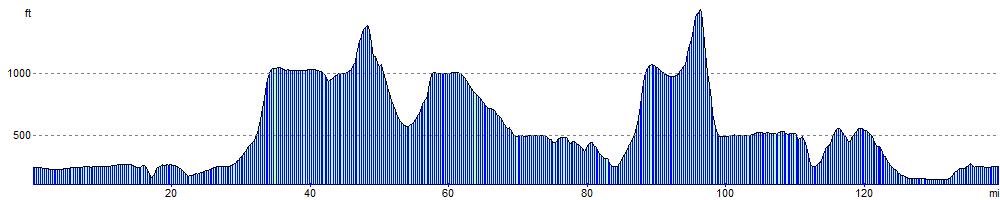
Elevation Profile