Slebech Park Walk
![]()
![]() This 600 acre estate is covered with miles of footpaths making it an excellent location for walkers. It sits on the Dau cleddau river Estuary and consists of Bluebell covered Beech wood, wildflower meadows and riverside paths. This circular walk starts from the car park and follows a very good path around the estate passing woodland and ponds. You finish with a riverside stretch along the Dau cleddau river.
This 600 acre estate is covered with miles of footpaths making it an excellent location for walkers. It sits on the Dau cleddau river Estuary and consists of Bluebell covered Beech wood, wildflower meadows and riverside paths. This circular walk starts from the car park and follows a very good path around the estate passing woodland and ponds. You finish with a riverside stretch along the Dau cleddau river.
If you'd like to continue your walking in the area then you could head a mile or so west to the wonderful Picton Castle Gardens. Canaston Woods is also nearby and has miles of good cycling and walking trails to try.
Slebech Park is located a few miles east of Haverfordwest.
Postcode
SA62 4AX - Please note: Postcode may be approximate for some rural locationsSlebech Park Ordnance Survey Map  - view and print off detailed OS map
Slebech Park Open Street Map  - view and print off detailed map
Slebech Park OS Map  - Mobile GPS OS Map with Location tracking
Slebech Park Open Street Map  - Mobile GPS Map with Location tracking
Further Information and Other Local Ideas
Just to the east there's the historic Blackpool Mill where there's some fine trails along the River Cleddau to try.
For more walking ideas in the area see the Pembrokeshire Coast Walks page.
Cycle Routes and Walking Routes Nearby
Photos
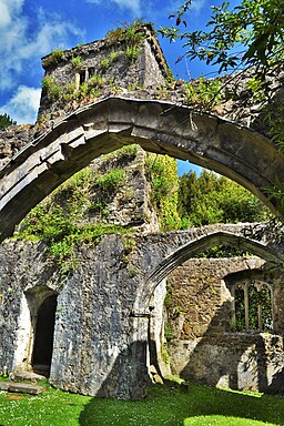
St John's, Slebech. The present church was built in 1838-40 (though not consecrated until 1848), but closed in 1990 due to subsidence. The church was built in a free Early English style, with tall lancet windows throughout, to designs of J.H.Good Jr., for Baron Rutzen of Slebech Park. It is constructed of grey limestone ashlar, generally with a pecked finish and some chiselling, slate roofs with large ogee gutters over a corbelled cornice, and two-stage buttresses with those at the corners capped with lumpish pinnacles.


