Slieve Donard from Newcastle Walk
![]() Climb to the highest peak in Northern Ireland on this challenging walk in the Mourne Mountains. It's a beautiful area with a waterside section along the Glen River a real highlight of the walk. The river has rocky pools, pretty waterfalls and surrounded by attractive woodland. The climb to the summit passes along the Mourne Wall which runs for 22 miles over 15 mountains. It was constructed in the early part of the 20th century.
Climb to the highest peak in Northern Ireland on this challenging walk in the Mourne Mountains. It's a beautiful area with a waterside section along the Glen River a real highlight of the walk. The river has rocky pools, pretty waterfalls and surrounded by attractive woodland. The climb to the summit passes along the Mourne Wall which runs for 22 miles over 15 mountains. It was constructed in the early part of the 20th century.
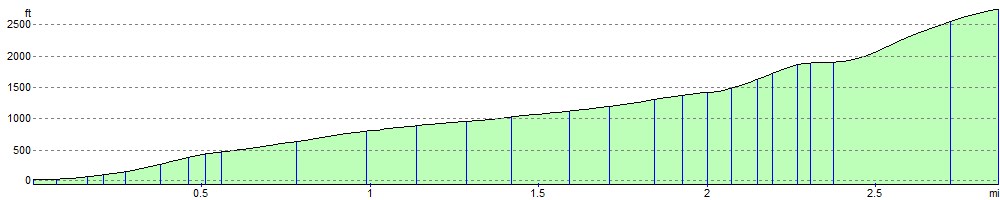
The walk starts from the attractive coastal town of Newcastle in County Down. After leaving the car park in Donard Park the route heads through the Scots Pine and Oak of Donard Forest. You'll follow the lovely Glen River Path to the Mourne Wall where you turn left to reach the 850m (2,789 ft) summit. From here the views are spectacular with Newcastle Beach, the Isle of Man, Scotland and Wales all visible on a clear day. Also at the summit you will find a small stone tower and two prehistoric burial cairns.
If you would like to extend your walking in the area then you could visit the nearby Tollymore Forest Park with its riverside walks and waymarked, woodland walking trails.
Also nearby is the splendid Murlough Bay National Nature Reserve where there is a beautiful sand dune system, woodland trails and a wonderful beach. For an easy stroll around Newcastle head to the pretty Islands Park in the town. It lies on the banks of the Shimna and Tullybrannigan Rivers, between the Bryansford Road, Bryansford Avenue and the Shimna Road.
Slieve Donard Open Street Map  - view and print off detailed map
*New* - Walks and Cycle Routes Near Me Map - Waymarked Routes and Mountain Bike Trails>>
Slieve Donard Open Street Map  - Mobile GPS Map with Location tracking
Pubs/Cafes
After your walk reward yourself with some refreshments at the popular Macken's Bar in Newcastle. There's a good atmoshpere and a garden to relax in duing the warmer months. You can find it at 73 South Promenade, with postcode BT33 0EY.
Further Information and Other Local Ideas
Head south west and you could enjoy another climb to Slieve Binnian. The challenging circular route includes views of the Mourne Wall and some wonderful granite tors.
To the south there's the Bloody Bridge Coastal Walk which visits a fascinating local historical site.
Cycle Routes and Walking Routes Nearby
Photos

A view of Sleive Donard from south-western edge of Annalong. The south face of Donard, the Mourne Wall is prominent as it rises towards the summit through the snow on the higher ground. The ridge in the foreground is known as the Bog of Donard.
_-_geograph.org.uk_-_971294.jpg)
Slieve Donard (late morning)

Donard dominates the view from Newcastle but it's not often as clear as this - sometimes a sign that rain is due.

The view of a thousand postcards – Newcastle promenade with the cloud-capped Mournes in the background. Donard forest is in the middle.

Slieve Donard Summit Cairn. This cairn is the highest point in Northern Ireland - at 852 metres (2,795 feet) above Mean Sea Level. There is memorial on top to a mountaineer who was killed by a lightning strike in 2006.

The summit of Slieve Donard. The summit of Slieve donard is crowned by a square shelter with a trig point on top. Picture taken from the Great Cairn nearby.

This well established path is the main route to Northern Ireland's highest peak

Sunny and snowy Slieve Donard lit by a celestial spotlight - seen from the Islands Park
Elevation Profile