St Peters Way
![]()
![]() Travel from Chipping Ongar to the 7th century St Peter's Chapel on St Peter's Flat on this walk through Essex.
Travel from Chipping Ongar to the 7th century St Peter's Chapel on St Peter's Flat on this walk through Essex.
The walk first heads to Maylandsea passing Hanningfield Reservoir and Purleigh on the way.
The second section heads to St Peter's Flat via Tillingham.
At the end of the route you could head west from the chapel to visit the village of Bradwell on Sea where there's a fine old pub for refreshment.
St Peters Way Ordnance Survey Map  - view and print off detailed OS map
St Peters Way Open Street Map  - view and print off detailed map
St Peters Way OS Map  - Mobile GPS OS Map with Location tracking
St Peters Way Open Street Map  - Mobile GPS Map with Location tracking
Pubs/Cafes
At Hanningfield Reservoir you could stop at the Cafe on the Water for some refreshments on the route. There is a lovely area outside on the decking with spectacular views over the Reservoir, which is open from April to November each year. It's the perfect place to relax on a warm summer day.
Cycle Routes and Walking Routes Nearby
Photos

High Street, Chipping Ongar. Route Start. Looking North - and a little to the North West of St Martin of Tours

Footpath to Sparrow Wycke Farm. This farm is in Mundon south of Maldon and stands on the St Peters Way long distance path.

Mundon Hall Moat.

This is the St Peter’s Way long distance path south of Black House Court Farm looking towards Tillingham.

Steeplewick Farm. This picture was taken from the footpath that runs from The St Peters Way on Bradwell Rd to Stansgate Abbey Farm

Footpath to Stansgate Abbey Farm

'The Bell' inn at Purleigh. This inn stands next to Purleigh parish church. It could be that part of the building sits in the next grid square.

St. Peter on the Wall. The 7th century church at the end of the route.
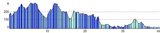
Elevation Profile