Staunton Way
![]()
![]() The Staunton Way takes you from Queen Elizabeth Country Park near Petersfield, through the South Downs to Staunton Country Park
near Havant.
The Staunton Way takes you from Queen Elizabeth Country Park near Petersfield, through the South Downs to Staunton Country Park
near Havant.
The start in Queen Elizabeth Country Park is particularly lovely with its acres of woodland and variety of wildlife. You then pass through the south downs enjoying splendid rolling countryside as you go. The end point is Staunton Country Park which boasts pleasure gardens, a lake and original glasshouses.
Click here for an excellent route guide from Hampshire County Council.
Staunton Way Ordnance Survey Map  - view and print off detailed OS map
Staunton Way Open Street Map  - view and print off detailed map
Staunton Way OS Map  - Mobile GPS OS Map with Location tracking
Staunton Way Open Street Map  - Mobile GPS Map with Location tracking
Further Information and Other Local Ideas
Just west of Chalton you could take a small detour to pick up the Clanfield Walk and visit Butser Ancient Farm and Windmill Hill. The farm is one of the area highlights and includes an archaeological open-air museum with reconstructions of Neolithic dwellings, Iron Age roundhouses, a Romano-British villa and an early Saxon house.
For more walking ideas in the area see the Hampshire Walks page.
Cycle Routes and Walking Routes Nearby
Photos

Pond at the Visitor Centre, Queen Elizabeth Country Park - route start.

Towards South Holt Farm. On the horizon, South Holt Farm, on the border between this square and the next one north. The valley in between is wooded (just see the tree tops here). The sign on the stile indicates the Staunton Way, a path between Staunton Park near Havant and Queen Elizabeth Country Park near Petersfield.

Signs for the Staunton Way and Church, Chalton. The trail is named after Sir George Staunton, an early 19th century Portsmouth MP who created a country estate. It passes through Chalton, Finchdean and Rowlands Castle.

Chalton Down

Finchdean. This waymark of the deer's head is on Wellsworth Lane which is simply a footpath at this point. The footpath also carries the Sussex Border Path.

Old Idsworth seen from the trail on Idsworth Down

Leaving Rowlands Castle. Leaving the woodland, the trail heads invitingly north in open countryside.

Lake at the end of the route in Staunton Country Park
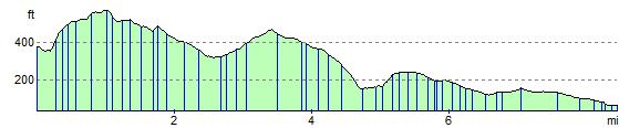
Elevation Profile