Taith Ardudwy Way - Barmouth to Llandecwyn
![]()
![]() This walk takes you through the Snowdonia National Park from Barmouth, on the Mawddach Estuary, to Llandecwyn. The route is divided into three sections:
This walk takes you through the Snowdonia National Park from Barmouth, on the Mawddach Estuary, to Llandecwyn. The route is divided into three sections:
Southern: Barmouth to Tal y Bont (8 miles)
Central: Tal y Bont to Harlech(13 miles)
Northern: Harlech to Llandecwyn (12 miles).
Highlights on the walk include the lovely views of the Mawddach Estuary at Barmouth (video below), fabulous views of the Rhinogydd range of mountains in Snowdonia and the Bryn Cader Faner Bronze Age round cairn towards the end of the route. Also look out for buzzards and red kites as these are regularly seen on the trail.
There are challenging climbs on the walk but you will be rewarded with some of the best coastal/mountain views in Wales.
The walk is waymarked with a Buzzard logo.
In Barmouth the route links with the Mawddach Trail. A splendid cycling and walking trail which takes you along the Mawddach Estuary.
Please click here for more information
Taith Ardudwy Way Ordnance Survey Map  - view and print off detailed OS map
Taith Ardudwy Way Open Street Map  - view and print off detailed map
Taith Ardudwy Way OS Map  - Mobile GPS OS Map with Location tracking
Taith Ardudwy Way Open Street Map  - Mobile GPS Map with Location tracking
Cycle Routes and Walking Routes Nearby
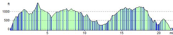
Elevation Profile