The Hangman Hills
![]()
![]() A challenging circular walk visiting Little Hangman and Great Hangman Hills near Combe Martin in Devon.
A challenging circular walk visiting Little Hangman and Great Hangman Hills near Combe Martin in Devon.
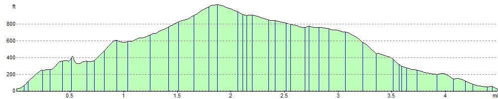
The walk starts in Combe Martin and heads east to Little Hangman Hill via Lester Point. You continue by climbing the 1044 feet (318 metres) high Great Hangman Hill. It is England's highest sea cliff and the highest point on the South West Coast Path. At the summit you wil find a cairn and can enjoy fabulous views over the surrounding coast and countryside. The route then descends through the countryside to Knap Down, before returning to Combe Martin. Here you can wander through the pretty village, admire the beautiful Combe Martin Bay and reward yourself with refreshments at one of the excellent pubs. There's also fine views over Holdstone Down and towards Lundy Island.
In the summer months look out for pretty flowers such as primroses and violets and wildlife including warblers and various coastal birds.
If you would like to extend your walking in the area then you could head east along the coast to the lovely Heddon Valley. Here you will find riverside walking trails and the imposing cliffs of Heddon's Mouth.
Postcode
EX34 0DH - Please note: Postcode may be approximate for some rural locationsThe Hangman Hills Ordnance Survey Map  - view and print off detailed OS map
The Hangman Hills Open Street Map  - view and print off detailed map
The Hangman Hills OS Map  - Mobile GPS OS Map with Location tracking
The Hangman Hills Open Street Map  - Mobile GPS Map with Location tracking
Explore the Area with Google Street View 
Further Information and Other Local Ideas
For more walking ideas in the area see the Devon Walks, the Exmoor Walks and the North Devon Coast Walks pages.
Cycle Routes and Walking Routes Nearby
Photos

Combe Martin: South West Coast Path to Great Hangman

Great Hangman. The South West Coast Path passes the cairn at Great Hangman, 318m above sea level.

180° view south from the summit of Great Hangman, the highest point on the South West Coast Path and the highest sea cliff in England.

View of Holdstone Down from Great Hangman. With Highveer Point to the left. Taken on the South West Coastpath

Combe Martin: west to Great Hangman. On Holdstone Down. Seen from the South West Coast Path, looking west

The footpath from Great Hangman. Looking west towards Little Hangman, Ilfracombe, and Lundy. Taken on the South West Coastpath.

Little Hangman from the east. This view of Little Hangman Hill was taken from the North Devon Coast Path, on the flanks of Great Hangman. These cliffs had a fine display of heather. Coombe Martin and its bay are hidden behind Little hangman.

Combe Martin: the climb to Little Hangman. The coast path ascends steeply towards Little Hangman and then diverges eastwards towards Great Hangman
Elevation Profile