The Miner's Way
27.3 miles (44 km)
![]()
![]() This circular walking trail passes through the attractive countryside of East Kent with the remains of the collieries, colliery villages and the East Kent Railway providing a historical theme to the walk.
This circular walking trail passes through the attractive countryside of East Kent with the remains of the collieries, colliery villages and the East Kent Railway providing a historical theme to the walk.
Please click here for more information
The Miner's Way Ordnance Survey Map  - view and print off detailed OS map
The Miner's Way Open Street Map  - view and print off detailed map
The Miner's Way OS Map  - Mobile GPS OS Map with Location tracking
The Miner's Way Open Street Map  - Mobile GPS Map with Location tracking
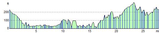
Elevation Profile