The Swan's Way
![]()
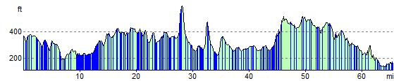
![]() The Swan's Way long distance bridleroute runs from Salcey Forest in the north to Goring on Thames in the south, a distance of 65 miles (105km). From the Northants border, the route crosses the Vale of Aylesbury to meet the Ridgeway near Princes Risborough and then follows the chalk slopes of the Chilterns to the Thames at Goring.
The Swan's Way long distance bridleroute runs from Salcey Forest in the north to Goring on Thames in the south, a distance of 65 miles (105km). From the Northants border, the route crosses the Vale of Aylesbury to meet the Ridgeway near Princes Risborough and then follows the chalk slopes of the Chilterns to the Thames at Goring.
It passes through varied countryside from beech woods on chalk scarp to low vales and ancient woodlands.
This route was submitted by Mark Worthington.
The Swan's Way Ordnance Survey Map  - view and print off detailed OS map
The Swan's Way Open Street Map  - view and print off detailed map
The Swan's Way OS Map  - Mobile GPS OS Map with Location tracking
The Swan's Way Open Street Map  - Mobile GPS Map with Location tracking
Pubs/Cafes
In Lewknor there's The Leathern Bottle for a pit stop on the trail. It's an historic pub of some note dating all the way back to the 1600s. The Grade II listed pub serves good quality food and includes a splendid large garden area to relax in on warm summer days. They have a large car park so the pub makes a good start point for a walk in the area.
Cycle Routes and Walking Routes Nearby
Photos

View from road between Eythrope and Stone. This view to the south-east from about 1.5km along the private road from Stone to Eythrope Park, is of the northern edge of a wood, The Nursery, with Starveall Farm in the middle distance to the right. The private road is a bridleway and is on the route of the Midshire's Way and Swan's Way.

Swan's Way by Christmas Gorse

Swan's Way on the top of Quainton Hill

Houses, Eythrope Road. These houses are on the edge of the village of Stone from where the road is coming. At this point, behind the camera, the road becomes a private road to Eythrope Park though it is a bridleway and is on the route of the Midshire's Way and Swan's Way.

Bridleway to Eythrope Park

Farmland, South Stoke. Looking down from the Swan's Way to the west of Watch Folly. The grassy strips are the runways of the Chiltern Park Aerodrome.
Elevation Profile