Three Castles Walk
![]()
![]() Visit the three Norman fortresses of Skenfrith, White Castle and Grosmont on this beautiful circular walk through Monmouthshire.
Visit the three Norman fortresses of Skenfrith, White Castle and Grosmont on this beautiful circular walk through Monmouthshire.
The trail takes the walker through woodland and over hills including Graig Syfyrddin (Edmund's Tump), from which there are spectacular views of the Welsh Marches, the Black Mountains and the Forest of Dean.
The walk is waymarked with a brown and white disc featuring a castle.
Please click here for more information
Three Castles Walk Ordnance Survey Map  - view and print off detailed OS map
Three Castles Walk Open Street Map  - view and print off detailed map
*New* - Walks and Cycle Routes Near Me Map - Waymarked Routes and Mountain Bike Trails>>
Three Castles Walk OS Map  - Mobile GPS OS Map with Location tracking
Three Castles Walk Open Street Map  - Mobile GPS Map with Location tracking
Pubs/Cafes
In Skenfrith you could enjoy a pit stop at The Bell. The restaurant here serves high quality food for which it has won many awards including the ‘Best Place to Eat – Pub’ in the Wales National Tourism Awards. There's also the Dog and Boot Bar which is better for muddy walkers and their four legged friends. You can find them at postcode NP7 8UH for your sat navs.
Further Information and Other Local Ideas
At the western end of the walk near the White Castle you can pick up the Offa's Dyke Path. Near here you also have the option of climbing to one of the highlights of the area at Skirrid Fawr. There are some wonderful views over Monmouthshire from this popular viewpoint.
Cycle Routes and Walking Routes Nearby
Photos

Defensible positioning of Skenfrith Castle. Skenfrith Castle is now run by the National Trust. The ruins date from the 13th century and are positioned beside the River Monnow.

Curtain Wall at White Castle. The ruined castle is located near the village of Llantilio Crossenny. In 1135, a major Welsh revolt took place and in response King Stephen brought together White Castle and its sister fortifications of Grosmont and Skenfrith to form a lordship known as the "Three Castles", which continued to play a role in defending the region from Welsh attack for several centuries.

Grosmont Castle. The fortification was established by the Normans in the wake of the invasion of England in 1066, to protect the route from Wales to Hereford. Edward I's conquest of Wales in 1282 removed much of Grosmont Castle's military utility, although it was besieged in 1405 during the Glyndŵr Rising. By the 16th century it had fallen into disuse and ruin. The castle was placed into the care of the state in 1922, and is now managed by the Cadw Welsh heritage agency.

View to Graig Syfyrddin, a 423m high hill near Grosmont. The summit knoll is known as Edmund's Tump. The path passes over the hill providing some excellent views.

Ysgyryd (Skirrid) Fawr and Sugar Loaf viewed from the slopes of Graig Syfyrddin on the Three Castles Walk.

View of Grosmont from the trail, above Cross on the northern slopes of Graig Syfyrddin.

A flat section before heading to High Meadow in the distance and then on to Grosmont.

Farm track near Llangattock-Vibon-Avel in Monmouthshire.
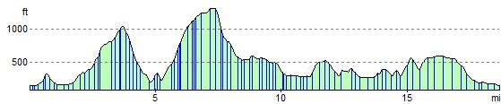
Elevation Profile