Two Ridges Link - Ivinghoe - Slapton - River Ouzel Walk
8.1 miles (13 km)
![]()
![]() This lovely, easy walk links The Ridgeway National Trail and the Greensand Ridge Walk.
This lovely, easy walk links The Ridgeway National Trail and the Greensand Ridge Walk.
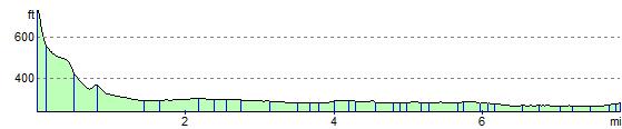
You start on Ivinghoe Beacon, with terrific views of the surrounding area, and head towards Slapton where you join the Grand Union Canal taking you to Leighton Buzzard.
Two Ridges Link Ordnance Survey Map  - view and print off detailed OS map
Two Ridges Link Open Street Map  - view and print off detailed map
Two Ridges Link OS Map  - Mobile GPS OS Map with Location tracking
Two Ridges Link Open Street Map  - Mobile GPS Map with Location tracking
Cycle Routes and Walking Routes Nearby
Photos

The start of the Two Ridges Link walk from the foot of the Ivinghoe Hills to Leighton Buzzard. View to the North West from Tring Road, with Ivinghoe Aston lying in the hollow in the distance

River Ouzel at Leighton Buzzard

"The Village Swan", Ivinghoe Aston

"Carpenters Arms", Slapton
Elevation Profile