River Wantsum Walk
![]()
![]() This is a super walk from Herne Bay to Birchington which includes both coastal and riverside stretches.
This is a super walk from Herne Bay to Birchington which includes both coastal and riverside stretches.
You start off at the pier in the delightful Herne Bay and follow the coastline to Bishopstone Manor. Here you turn inland through Chislet Marshes towards Upstreet, where you join the River Great Stour for some riverside walking. You continue through Sarre and St Nicholas at Wade, before rejoining the coast path to Birchington, finishing near the train station.
This is just one of the Wantsum Walks which pass through the area and can be viewed on OS maps.
Please click here for more information
Wantsum Walk Ordnance Survey Map  - view and print off detailed OS map
Wantsum Walk Open Street Map  - view and print off detailed map
Wantsum Walk OS Map  - Mobile GPS OS Map with Location tracking
Wantsum Walk Open Street Map  - Mobile GPS Map with Location tracking
Pubs/Cafes
At Herne Bay we recommend heading to the seaside Four Fathoms for some refreshments. The popular pub was voted Kent Life pub of the Year and includes a lovely courtyard garden where you can take in the wonderful fresh sea air in the sheltered surroundings. They do wonderful food and can be found on the High St, Herne Bay, with a postcode of CT6 5LH for your sat navs.
Further Information and Other Local Ideas
For more walking ideas in the area see the Kent Walks page.
Cycle Routes and Walking Routes Nearby
Photos

The Wantsum Walk. A well defined track at this point

Minnis Bay

Part of the Wantsum Walk near Chitty

River Wantsum on Wantsum Way path. Good fishing river. Note:Margate to London Railway line Bridge in background.

Chislet Marshes

Near Reculver. Looking east along the Rushbourne Sea Wall. A little way past the bush a path turns north and returns to the Northern Sea Wall, while the Wantsum walk continues on the Rushbourne Sea Wall, turning south just beyond the ploughed field.

Coastguard lookout from the trail.

Chambers Wall
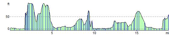
Elevation Profile