Forest Way
![]()
![]() This cycling and walking route runs from East Grinstead to Groombridge following National Cycle Route 21 along a flat tree lined path. The path is also a designated country park.
This cycling and walking route runs from East Grinstead to Groombridge following National Cycle Route 21 along a flat tree lined path. The path is also a designated country park.
The trail follows a disused railway line route and has splendid views of the rolling hills of the downs and local farmland.
Please click here for more information on this route.
Weir Wood Reservoir is just to the west of the route so you could visit this lovely nature reserve if you have time.
Forest Way Ordnance Survey Map  - view and print off detailed OS map
Forest Way Open Street Map  - view and print off detailed map
Forest Way OS Map  - Mobile GPS OS Map with Location tracking
Forest Way Open Street Map  - Mobile GPS Map with Location tracking
Pubs/Cafes
In East Grinstead The Ship Inn is a good choice for some refreshments. They do very good food and have an attractive interior with a cosy fire for cold days. If the weather is fine there's a nice terraced garden outside too. You can find the pub on Ship Street at a postcode of RH19 4EG for your sat navs.
At the other end of the route there's the Crown Inn in Groombridge. It's located in a great spot just across the road from Groombridge Place. The historic 16th century pub is one of the oldest in the South of England. There's a charming interior with a cosy beamed restaurant and log fires. They do high quality food and can be found at a postcode of TN3 9QH.
Further Information and Other Local Ideas
At the end of the route you'll find Groombridge Place Gardens. Here you can explore beautiful, award winning gardens surrounding a fine moated manor house.
For more walking ideas in the area see the Sussex Walks page.
Cycle Routes and Walking Routes Nearby
Photos

Two-arched Bridge On the Forest Way, the old East Grinstead - Tunbridge Wells railway. The over-bridges here appear built for double track, the cutting for single track.

Bridge over Forest Way at Luxfords Woods. Luxfords Lane crosses the old East Grinstead to Tunbridge Wells railway, now the Forest Way trail. The section from Forest Row in the Medway valley up to the heights of East Grinstead was known as Brambletye Bank. The steady uphill incline is still a drag to cyclists, but easy going the other way, of course.

Bullocks near Hartfield. Just north of the Forest Way - the Medway forms the lower field boundary.

Forest Way 10 mile cycle & walking route from East Grinstead to Groombridge. The route of an old railway, built 1866, closed 1966. This section is between Forest Row and Hartfield.

Crossing Herontye Drive, East Grinstead

The High Weald Landscape Trail seen from the former East Grinstead to Tunbridge Wells Railway
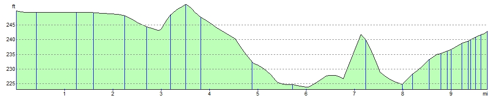
Elevation Profile